
Written by: Paul Foster, Founder, CEO, OnePlan
Key Takeaways for Street-Fair Emergency Access
- Street fair emergency access routes must stay continuous and unobstructed and meet local fire-code width and clearance standards to pass inspection.
- Accurate, to-scale site plans are essential; non-scale drawings from tools like PowerPoint or Canva cause many inspection failures.
- Minimum lane widths vary by city, typically 14–20 feet, with extra clearance required around hydrants, intersections, and overhead structures.
- Using a live, collaborative mapping platform prevents version-control issues and keeps every department working from the same approved plan.
- OnePlan helps organizers create permit-ready emergency access maps that satisfy fire-marshal requirements; book a demo today to see how it streamlines your planning process.
Minimum Road Width Standards for Fire-Engine Access
The International Fire Code (IFC) sets a baseline minimum unobstructed width for fire apparatus access roads of 20 feet, exclusive of shoulders. IFC Appendix D requires a minimum fire apparatus access road width of 26 feet where a fire hydrant is located on the road, and aerial apparatus access roads must also have a minimum unobstructed width of 26 feet. The required minimum vertical clearance under any overhead structure, including temporary canopies, banners, or signage, is 13 feet 6 inches, which matches the height envelope of a fully extended aerial ladder truck, though some local jurisdictions prefer 14 feet.
For dead-end access roads longer than 150 feet, the IFC requires an approved turnaround such as a hammerhead or cul-de-sac. Road gradients generally must not exceed 10% unless the fire code official explicitly approves a steeper grade. Security gates crossing fire access roads must maintain the minimum 20-foot width, allow manual operation by one person, and account for the turn radius of the longest local fire apparatus.
A practical layout for a typical two-lane street fair closure places the 20-foot emergency lane down the center of the closed roadway. Vendor and activity zones then sit back on either side. Where a hydrant falls within the event footprint, the lane widens to the 26-foot hydrant standard at that point, and a minimum 3-foot clear radius stays open around the hydrant circumference on all sides. Every measurement must appear on the submitted site plan drawn accurately to scale, not estimated from a screenshot.
Requirements vary by jurisdiction. Always confirm the applicable width, clearance, and turnaround rules with your local fire code official before finalizing any site plan.
Marking Emergency Access Lanes at a Street Fair
Once you know the required lane dimensions for your jurisdiction, you need to mark those lanes clearly on the ground and in your documentation. San Francisco’s Rules for Special Event Safety require the 14-foot emergency access lane to sit preferably in the center of the roadway, with people permitted to occupy it but objects such as tents, tables, and chairs strictly prohibited. The same rules require that all intersections and pedestrian crosswalks remain completely clear of objects and vehicles to allow emergency vehicle movement, and that curb ramps stay accessible at all times.
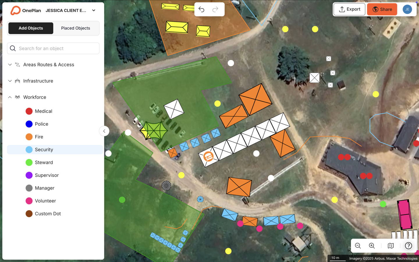
Standard marking and signage practices for emergency access lanes at street fairs include the following:
- Yellow circles or painted markers over fire hydrant locations on the ground surface, with a minimum 3-foot clear radius around the hydrant circumference and, in many jurisdictions, a 15-foot no-parking zone along the curb line on each side
- “FIRE LANE — NO PARKING” signage posted on both sides of the access lane at regular intervals, with signs at least 12 inches wide by 18 inches high in red letters on a white reflective background where required by local code
- Workforce dots, meaning staff or stewards stationed at key pinch points, intersections, and hydrant locations, who enforce lane clearance throughout the event
- Buffer zones between vendor footprints and the edge of the emergency lane, sized to prevent encroachment as crowds build
- Command post locations for Emergency Medical Services, police, and security identified on the site plan, as required by the San Francisco Fire Department’s site plan requirements
The Cheese & Chilli Festival uses OnePlan’s emergency vehicle route tools alongside evacuation calculators as part of its risk assessments and management plans, which shows how marking and documentation work together on a live map.
City-Specific Emergency Access Rules for Street Fairs (2025–2026)
Emergency access requirements differ significantly between jurisdictions. The table below summarizes published rules for three major U.S. cities as of 2025–2026. Every organizer must verify current requirements directly with the relevant fire code official, because local amendments, event size, and site conditions all affect what applies.
| City | Minimum Emergency Lane Width | Hydrant / Intersection Clearance |
|---|---|---|
| New York City | New York City requires a 15-foot minimum emergency access lane for events and street activations | 15 ft clearance from hydrant to nearest vehicle or object; intersections must remain clear |
| San Francisco | 14 ft minimum running the full length of the event (objects prohibited; people permitted) | 5 ft clear zone around every hydrant, fire alarm box, and police call box; all intersections and crosswalks clear of objects |
| Seattle | Seattle requires a minimum 20-foot emergency vehicle access lane for special-event street closures | 3 ft clear radius around hydrant circumference; 15–20 ft no-parking zone along curb line |
San Francisco’s 14-foot rule is a city-specific special-event standard that differs from the IFC baseline. Always confirm requirements with the applicable fire code official for your specific event and location.
Common Fire-Marshal and Police Inspection Failures at Street Fairs
Inspection failures at street fairs cluster around a predictable set of problems, and most start in the planning stage rather than on event day.
- Inaccurate measurements on site plans. Plans produced in PowerPoint, Excel, Canva, Photoshop, Google Maps, or static screenshots are not drawn to scale. A tent or vendor stall that appears to leave a 20-foot lane on a non-scale plan may reduce the actual clearance to 14 feet on the ground, which triggers an immediate failure.
- Blocked fire hydrants. Vendors or temporary structures placed too close to hydrants, often because the hydrant location was not accurately plotted on the plan, violate the minimum clearance rules and require last-minute relocation on inspection day.
- Obstructed intersections. Signage, fencing, or vendor footprints that encroach into intersections prevent emergency vehicles from turning, a common failure point flagged by both fire marshals and police.
- Version-control chaos. When departments such as operations, security, traffic, fire, and police each work from their own copy of the plan, the version submitted for approval may not match what is actually set up on site. Before adopting OnePlan, the City of Greater Dandenong created site plans using Microsoft Word or PDFs with added symbols, which often featured outdated maps, non-scale layouts, and imprecise emergency location markings.
- Underestimated infrastructure quantities. Organizers who cannot accurately calculate how much fencing, barrier, or signage they need end up with gaps in the emergency lane perimeter or missing “FIRE LANE” signs at required intervals.
- Missing or incomplete documentation. San Francisco requires site plans to be printed on at least 11×17-inch paper and drawn to scale. Plans that omit required elements are returned for revision, which delays approval.
Plan your next event the easy way. Get started free at OnePlan, where your first event is on us, or book a 15-minute demo to see OnePlan in action.
7-Step Workflow to Create Permit-Ready Emergency Access Maps
This workflow produces a continuous, compliant emergency access map that satisfies fire-marshal and police documentation requirements, with each step building on the last.
- Gather local fire-access ordinances. Contact the fire code official and police department for your specific jurisdiction. Confirm the minimum lane width, vertical clearance, hydrant clearance distances, intersection rules, turnaround requirements, and submission format before drawing anything. Requirements vary by city, county, and state.
- Import your street-fair footprint as a .png base layer. Convert any existing site plan, aerial image, or CAD-derived file to .png and import it into OnePlan. Scale it onto the live satellite map so every subsequent measurement is geo-accurate and to scale from the start.
- Draw continuous emergency lanes to scale. Use OnePlan’s to-scale drawing tools on the live map to plot the emergency access lane running the full length of the event footprint. Confirm the lane width meets the local minimum, at least 20 feet under IFC §503.2.1 in most U.S. jurisdictions, widening to the 26-foot hydrant standard wherever a hydrant falls within the lane. The area and perimeter calculator returns exact dimensions instantly.
- Apply clearance buffers around hydrants, intersections, and fixed objects. Start by placing clearance buffer zones around every fire hydrant, with a minimum 3-foot radius and, in many jurisdictions, 15 feet along the curb line. Next, keep all intersections and crosswalks clear of objects, because emergency vehicles rely on these spaces for turning. Finally, maintain the required 13-foot-6-inch vertical clearance under any overhead structure such as canopies, banners, or signage. Mark each buffer visibly on the plan so inspectors can verify compliance quickly.
- Place workforce and signage dots. Use OnePlan’s workforce dot tools to position stewards, fire-lane marshals, and command post locations at hydrant points, lane pinch points, and intersections. Add “FIRE LANE — NO PARKING” signage objects at the intervals required by local code. Assign shift times and notes to each dot for the event-day staffing record.
- Run traffic and crowd-flow checks. Use OnePlan’s traffic management tools to verify that ingress and egress routes do not conflict with the emergency lane, that vendor and crowd areas do not encroach on the lane perimeter, and that the standing crowd capacity of each zone is calculated and documented. Use OnePlan’s exit flow calculator to confirm evacuation capacity at each exit point.
- Export high-resolution maps and Bill of Quantities. Export a print-ready, high-resolution map (up to A0) showing all emergency lanes, hydrant clearances, signage, workforce positions, and command posts, with a legend explaining every symbol, as required by authorities such as the San Francisco Fire Department. The auto-generated Bill of Quantities exports to Excel or CSV and gives you an exact count of every barrier segment, sign, and cone needed to build the plan on the ground.
“Working with the City of Lewisville’s Health and Safety Department was much simpler thanks to OnePlan. Being able to share detailed plans for roadblocks, crowd control, and traffic management meant we got the necessary approvals quickly and without headaches.” — Evelin Costa, North Texas Tribute Jam
Ready to create permit-ready emergency access maps? Start your first event free or schedule a 15-minute demo to see how OnePlan streamlines fire-marshal approvals.
Planning Tools: Manual Methods vs. Specialized Mapping Platforms
Most street fair organizers still plan emergency access routes using PowerPoint, Excel, Canva, Photoshop, Google Maps, or internal static, top-view screenshots and plan files. None of these tools produce plans that are to scale. A lane drawn on a non-scale screenshot may look compliant but measure 12 feet on the ground. Hydrant locations often get estimated rather than plotted. Version control then breaks down as emailed files diverge across departments, which produces a plan that fails inspection or, worse, a lane that is blocked on event day because the approved plan did not reflect reality.
At the other extreme, CAD and AutoCAD deliver precision but require specialist training, carry significant cost, and produce static files that fire marshals, police, and non-technical stakeholders may struggle to read and act on quickly.
Specialized event mapping platforms sit in the practical middle ground. OnePlan’s base layer is a live, zoomable satellite or street map built on leading GIS technology. Every object placed on it, including emergency lane boundaries, hydrant clearance buffers, signage, and workforce dots, stays accurately to scale at any zoom level. Multiple departments work in the same live plan simultaneously, so the version submitted for approval is always the version being built on the ground. Stadium planned Coventry Moves, an event with over 12 hours of traffic closures, 400 individual closures across 7 procession routes, and 110 stakeholders, using OnePlan and reduced planning time from over 200 hours to 75 hours.

Common Emergency Access Challenges and How to Avoid Them
Four recurring challenges account for most emergency access planning failures at street fairs.
- Inaccurate measurements. Mitigation: plan on a live, to-scale satellite map from the first draft. Use the area and perimeter calculator to confirm lane widths before placing any vendor or infrastructure object.
- Version-control chaos. Mitigation: maintain one live plan that all departments, including operations, security, traffic, fire, and police, access simultaneously. “Gone are the days of creating separate layouts for fire, police, facilities, and other departments. Now I can create a single, all-encompassing layout.” — Dawn Hancock, Events Manager, Eagle Mountain City
- Last-minute rejections. Mitigation: submit site plans well ahead of the required deadline and build in time for the revision requests that fire departments commonly issue after initial review.
- Underestimated infrastructure quantities. Mitigation: use the auto-generated Bill of Quantities to convert every object on the map into an exact procurement list. Draw a line of crowd barriers and OnePlan returns the precise number of segments needed, which removes guesswork from orders.
Measuring Success: Signs Your Emergency Access Plan Works
A well-designed emergency access plan produces clear, measurable improvements before and during the event.
- Fewer site visits. When the plan is accurate to scale from the desk, organizers stop making repeated trips to measure lanes by hand. The City of Greater Dandenong reported saving time and money through accurate site plans and fewer site visits after implementing OnePlan, with the measuring tool proving invaluable for setting safe exclusion zones without unnecessary field trips.
- Faster approvals. Plans that are to scale, include all required elements such as lane widths, hydrant locations, legend, and command posts, and arrive on time move through fire-marshal and police review with fewer revision cycles.
- Reduced rework on event day. When the approved plan matches what is built on the ground, because the same live plan was used throughout, last-minute relocations of vendors, signage, or barriers become rare instead of routine.
Advanced Planning: Reusable Templates and Multi-Year Standardization
Street fairs that recur annually on the same route gain major benefits from reusable plan templates. Once a compliant emergency access layout is approved, with lane widths, hydrant clearances, signage positions, and workforce dots all confirmed by the fire marshal and police, that plan becomes the starting point for every subsequent year. Organizers then update vendor placements, crowd areas, and infrastructure as needed without rebuilding the emergency access framework from scratch.
OnePlan supports this approach directly. Recurring events save their base map, import updated satellite imagery as a .png overlay when the streetscape changes, and adjust objects on top of the proven emergency access skeleton. The Bill of Quantities updates automatically as objects change, so procurement lists stay current without manual re-entry. For local government events teams managing multiple fairs across a calendar year, standardized templates also ensure that every event submitted for approval meets the same documented baseline, which reduces the risk of one-off errors slipping through on a rushed plan.
Frequently Asked Questions
How far in advance should I submit an emergency access plan to the fire marshal?
Submission deadlines vary by jurisdiction and event size. Raleigh requires special event permit applications 30–120 days before the event depending on type. As a general rule, submit your site plan and emergency access documentation at least 45 to 60 days before the event to allow time for revision requests, which fire departments commonly issue after initial review. Always confirm the specific deadline with your local fire code official and special events office.
Who needs to approve an emergency access plan before a street fair can open?
Approval typically involves multiple agencies. The fire marshal or fire department reviews the site plan for lane widths, hydrant clearances, vertical clearance, and overall fire code compliance. The police department reviews traffic control, crowd management, and pedestrian safety. In many cities, a special events office or outdoor public events committee coordinates sign-off across all agencies before a final permit is issued. Boston, for example, requires the permit application to be signed by the Police Captain and other committee members before the Mayor’s Office issues the final permit. Some jurisdictions also require separate permits for tents, generators, stages, and temporary structures, each with its own fire department review.
What documentation must a street fair site plan include to satisfy fire-marshal requirements?
Requirements vary, but a useful benchmark includes the event name, dates, and times; anticipated attendance; street names, widths, and addresses; fire lane locations with widths labeled; locations of all existing fire infrastructure including hydrants, standpipes, sprinkler inlets, and fire escapes; all exits with pathway widths noted; command post locations for Emergency Medical Services, police, and security; and a legend explaining every symbol used. Plans must be drawn to scale, not estimated from a screenshot, and printed on at least 11×17-inch paper where required. Large events may require a separate exit plan drawing. Always confirm the exact documentation checklist with the fire department in your specific city.
Can a small street fair with fewer than 500 attendees skip a formal emergency access plan?
Small events rarely avoid emergency access requirements. Many jurisdictions set the threshold for a formal Emergency Action Plan at 1,000 attendees, but fire code requirements for minimum lane widths and hydrant clearances apply whenever a street is closed for a public event, regardless of crowd size. Even for smaller fairs, a to-scale site plan showing the emergency lane is standard documentation for any street closure permit. Confirm the threshold and requirements with your local special events office.
How does OnePlan help street fair organizers pass fire-marshal inspections?
OnePlan replaces non-scale planning tools with a live satellite map on which every object, including emergency lane boundaries, hydrant clearance buffers, vendor footprints, signage, and workforce positions, stays accurately to scale at any zoom level. The area and perimeter calculator confirms lane widths instantly. The auto-generated Bill of Quantities converts every object on the map into an exact count of barriers, signs, and cones needed to build the plan on the ground. Plans export as high-resolution, print-ready maps with a legend, which meets the documentation format required by fire departments. Because all departments work in the same live plan, the version submitted for approval matches what is built on site and removes the version-control failures that cause last-minute inspection rejections.
Conclusion: Build Compliant Emergency Access Routes the Easy Way
Designing emergency access routes that pass fire-marshal and police inspections is a documentation challenge as much as a layout challenge. The lane widths, hydrant clearances, vertical clearances, and intersection rules already exist in the IFC and local codes. The failure point almost always sits in the plan itself, with non-scale drawings that misrepresent actual clearances, version-control chaos that puts different maps in the hands of different agencies, and missing documentation that sends plans back for revision at the last minute.
The 7-step workflow above, from gathering local ordinances through exporting permit-ready maps and a Bill of Quantities, addresses every stage of that process. OnePlan is the platform that makes each step faster and more accurate, with a live, to-scale satellite map where emergency lanes, hydrant buffers, signage, and workforce dots are placed with precision, all departments work from one single source of truth, and the final export meets the documentation standard fire marshals and police require.
OnePlan has powered more than 200,000 events in 150 countries, from community street fairs to the Paris 2024 Olympic Games. Your first event is free.
Plan your next event the easy way. Book your demo today and start your first event free in OnePlan.