
Written by: Paul Foster, Founder, CEO, OnePlan
Key Takeaways
- A special-event safety plan is a structured document that explains how organizers will protect attendees, staff, and the community. It covers site layout, crowd capacity, access, medical provision, security, traffic, communications, and contingencies.
- Authorities typically require 12 specific sections, each backed by clear visual and numerical deliverables such as to-scale site maps, capacity calculations, and staffing schedules.
- OnePlan helps event professionals create geo-accurate maps, calculate crowd capacity, and generate Bills of Quantities automatically, cutting planning time by up to 85% compared with manual tools.
- Local jurisdiction requirements vary widely, so organizers should confirm submission formats, lead times, and thresholds with their city or county before preparing any section.
- Book a demo with OnePlan to see how the platform helps you create submission-ready safety plans faster and with greater accuracy.
Core Requirements for a Special Event Safety Plan
According to the OnePlan 2026 Event Site Planning Report, 71% of event professionals rank attendee safety and security as their top site-planning priority. The 12 sections below represent the core deliverables that fire, police, and licensing authorities consistently require. Requirements vary by jurisdiction, so confirm the exact submission format with your city or county before filing.
Local Jurisdiction Check: Every city, county, and state sets its own submission requirements, lead times, and formats. Confirm the exact checklist with your local authority before preparing any section of your safety plan.
- Event Overview and Site Description
Provide the event name, date, times, location, and a brief description of activities. Include the total site acreage and a summary of all temporary structures. For example, in Sarasota, Florida, event sponsors must submit a permitting application, and requirements differ by state and municipality.
- Submit this to authorities: A one-page event summary with site address, GPS coordinates, and a high-resolution site overview map.
- OnePlan tool: Export a print-ready PNG overview map (up to A0) directly from your OnePlan plan, with a legend generated automatically.
Provide a dimensionally accurate map showing all infrastructure, including stages, tents, barriers, toilets, generators, food stalls, and signage, positioned to scale on the actual venue footprint. In New York City, the threshold for requiring formal permits is lower than in many other states. Tents over 400 square feet require a permit from the Department of Buildings, while stages exceeding 120 square feet in area and 9′-6″ in height require a Temporary Use Permit filed by a registered design professional. These thresholds mean that even modest temporary structures often need dimensionally accurate site maps.

Beach event planning example inside OnePlan: the base layer is a zoomable satellite or street map, and everything placed on it (tents, stages, crowd barriers, toilets, vehicles, staff, signage, routes) stays accurately to scale as you zoom - Submit this to authorities: A geo-accurate, to-scale site map with a north arrow, scale bar, and labeled infrastructure.
- OnePlan tool: OnePlan’s base layer uses live satellite or street maps built on Esri GIS technology. Every object, from a 10×20 ft tent to hundreds of feet of crowd barriers, stays accurately to scale as you zoom. SoulFest built almost its entire festival map within two days, cutting planning time by 85%.
Document the maximum standing capacity for each crowd zone, supported by area measurements and the density assumptions used. High crowd density can create critical conditions, so defensible capacity data becomes a non-negotiable deliverable. Avoid estimates and rely on measured area data instead.
- Submit this to authorities: A capacity table listing each crowd zone by name, measured area in square feet, density assumption, and calculated maximum standing occupancy.
- OnePlan tool: OnePlan’s crowd capacity calculator lets you outline any area on the map and instantly calculate its maximum standing capacity based on a selectable density. Note: OnePlan calculates standing capacity only. Use OnePlan’s free arrival calculator and exit calculator to model queue lengths and egress flow.
Map all entry and exit points, pedestrian routes, and emergency evacuation corridors with widths labeled. Building codes require egress pathways that are stable and slip-resistant, with fire apparatus clearance around tent structures. This standard illustrates the level of specificity authorities expect, although exact requirements vary by jurisdiction. NFPA 101 requires the main entrance or exit of an assembly occupancy to accommodate at least half of the total occupant load, with higher thresholds for nightclub-type occupancies.
- Submit this to authorities: A route map with labeled widths, surface types, and a written evacuation sequence.
- OnePlan tool: Place entry and exit point-of-interest icons and draw pedestrian routes directly on the map. Use the area and perimeter calculator to confirm corridor widths meet local requirements. Run the free exit calculator to estimate exit capacity based on exit width, crowd size, and flow rate.
Explain road closures, vehicle access points, parking areas, and pedestrian crossing locations. In Sarasota, Florida, events requiring road closures must hire extra duty officers, with staffing requirements determined by the Sarasota Police Department based on attendee numbers, alcohol availability, and event history. This example shows how traffic and security planning are often reviewed together.
- Submit this to authorities: A traffic management map showing road closures, signage placement, vehicle access routes, and parking capacity figures.
- OnePlan tool: OnePlan’s traffic and transport tools handle road closures, vehicle access points, and parking capacity calculations. Place cone lines, signage, and barriers directly on the map.
Identify all security post positions, patrol routes, and staffing levels. A dot map showing all security guard post positions should be reviewed and agreed upon by the venue, the security provider, and the event organizer before the event. In New York State, security guards must register through the NYS Division of Licensing Services, and firms providing such services must hold a Watch, Guard or Patrol Agency license, which differs from requirements in other states.
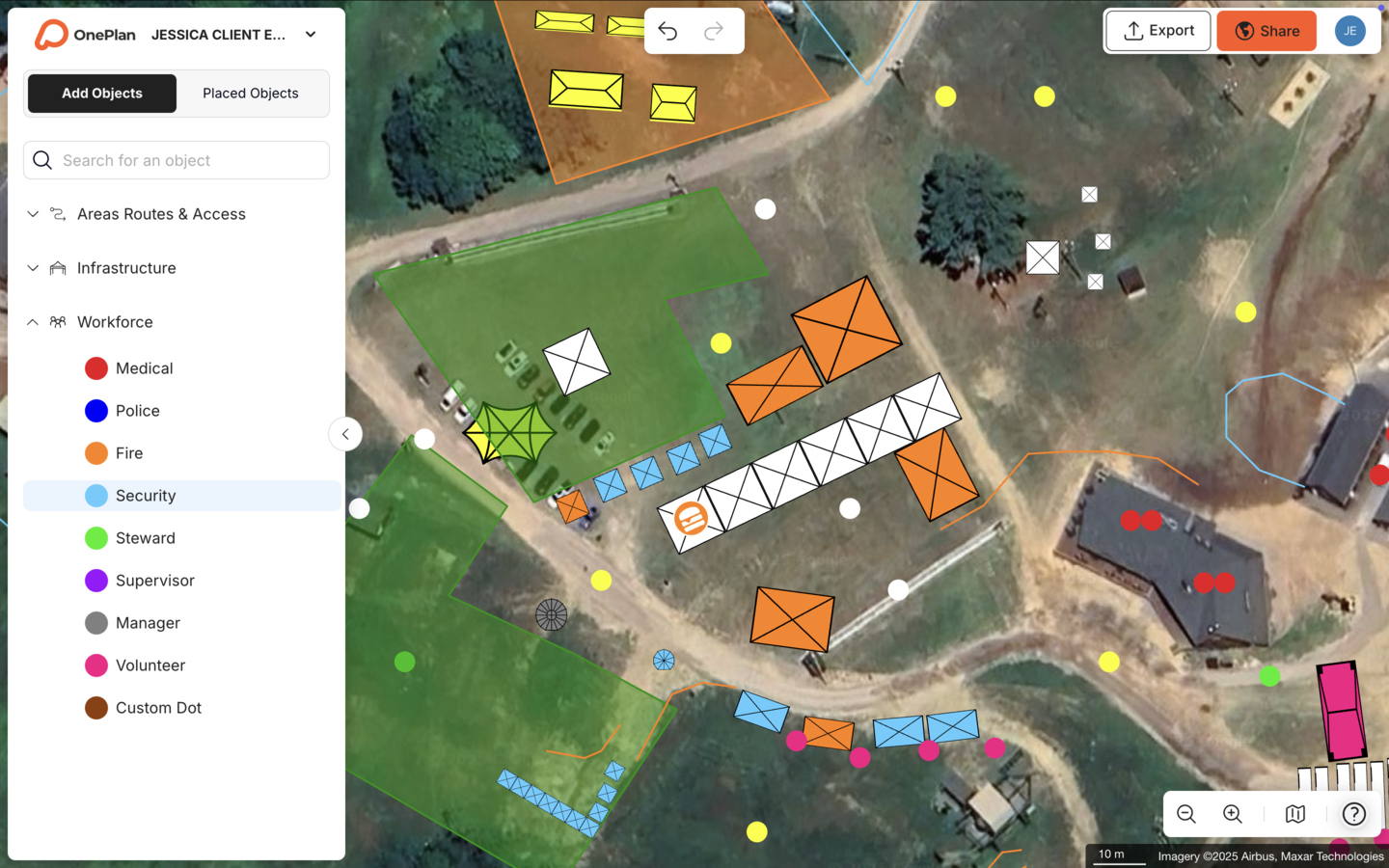
Workforce planning example inside OnePlan: the base layer is a zoomable satellite or street map, and everything placed on it (tents, stages, crowd barriers, toilets, vehicles, staff, signage, routes) stays accurately to scale as you zoom - Submit this to authorities: A security dot map with post positions labeled, plus a staffing schedule showing shift times and roles.
- OnePlan tool: Place workforce dots on the map for security, stewards, supervisors, and police liaison roles. Assign each dot a name, shift times, notes, and equipment. Export the full staffing plan as a CSV from the Bill of Quantities dashboard.
Specify the number and location of first aid posts, AED stations, and on-site medical personnel. Expert consensus from a 2021 Delphi study published in the International Journal of Disaster Risk Reduction confirms that health professionals, not volunteers, must deliver on-site medical care, and that a dedicated situation room housing all essential stakeholders is required for effective mass gathering medical preparedness. EMT staffing levels vary with anticipated attendance, seating configuration, and event type, and most jurisdictions require EMTs on site as first responders.
- Submit this to authorities: A medical provision map with first aid post locations, AED positions, and a written staffing schedule listing qualifications.
- OnePlan tool: Place first aid, medical, and AED point-of-interest icons on the map. Add medical staff as workforce dots with role, shift, and equipment details.
Document the number, type, and location of portable restrooms, hand-washing stations, and ADA-accessible units. Florida Department of Health rules for Sarasota special events require servicing of portable restrooms at least daily, and similar rules vary by state and county.
- Submit this to authorities: A facilities map with toilet and hand-washing station locations labeled, plus a quantity table cross-referenced against attendee numbers and event duration.
- OnePlan tool: Drag and drop portable toilet objects onto the map. The auto-generated Bill of Quantities counts every unit placed and exports the total to Excel or CSV for procurement and permit submission.
Provide engineering sign-off for all temporary structures, including stages, grandstands, and large tents. Engineering documentation must validate the structural suitability of the venue for specific loads including floor loading, roof capacity, electrical suitability, and loading dock access. In Sarasota, Florida, a tent exceeding 900 square feet requires a separate tent permit from the City of Sarasota Development Services, and thresholds differ from other jurisdictions.
- Submit this to authorities: A structural layout map with dimensions for every temporary structure, plus engineer certification documents where required.
- OnePlan tool: Place to-scale tent, stage, and grandstand objects on the map with exact dimensions. The area and perimeter calculator confirms footprints. Export a high-resolution map for the engineer’s review.
Create a written plan covering shelter-in-place protocols, evacuation triggers, staff communication chains, and contact information for local emergency services. In New York City, certain buildings and occupancies must maintain written fire safety and emergency action plans that address sheltering in place, evacuation, and related procedures. This requirement reflects best practice across most U.S. jurisdictions, although the exact format varies.
- Submit this to authorities: A written emergency action plan document paired with a site map highlighting evacuation routes, assembly points, and emergency vehicle access lanes.
- OnePlan tool: Mark assembly points, emergency access routes, and shelter locations using point-of-interest icons. Export the annotated map as a companion to the written plan.
Set trigger thresholds for weather-related decisions, such as lightning within a specified radius or sustained wind speed, and define evacuation routes and shelter locations. A concise Severe Weather Annex to the event risk assessment is a required deliverable that lists threat scenarios, trigger thresholds, impact areas, and initial mitigations, and should be integrated into contracts with contractors and stage-builders. Event organizers must monitor weather forecasts and prepare contingency plans for unpredictable conditions such as rain, wind, extreme temperatures, or storms.
- Submit this to authorities: A weather annex document with trigger thresholds, a decision tree, and a site map showing shelter locations and secondary evacuation routes.
- OnePlan tool: Add shelter-in-place locations and secondary egress routes to the existing site map. Share the updated live plan with all stakeholders so everyone sees the same contingency layout.
Compile a complete, itemized list of all infrastructure, including barriers, fencing, toilets, generators, signage, and staffing, with quantities, dimensions, and supplier details. This document supports contractor coordination, procurement accuracy, and post-event reconciliation. Eagle Mountain City cut event planning from 8–10 hours down to a few hours per event, a 70% time saving, by replacing siloed department maps with a single OnePlan layout that generates this inventory automatically.
- Submit this to authorities: An exported Bill of Quantities in Excel or CSV format, cross-referenced with the site map.
- OnePlan tool: Every object placed on the map saves automatically to the Bill of Quantities dashboard. Draw a line of crowd barriers and OnePlan counts the segments. Export the full inventory to Excel or CSV in one click, with no re-keying required.
Local Jurisdiction Check: Lead times for permit submissions vary significantly. Check your local authority’s deadlines early, because requirements differ by city, county, and state.
What Should Be Included in a Safety Plan
Understanding the required sections is only the first step. The 12 sections above form the structural backbone of any compliant safety plan, but the quality of each section depends on the accuracy of the underlying data. Authorities reviewing permit applications look for three things: visual clarity, numerical defensibility, and operational coherence.
Visual clarity means a to-scale site map that reviewers can read without ambiguity. Numerical defensibility means capacity figures and staffing ratios backed by measured areas. Operational coherence means a plan where the crowd flow, security posts, medical provision, and emergency routes all connect logically.
Manual tools such as PowerPoint, Excel, Canva, Photoshop, Google Maps, or internal static screenshots rarely deliver all three. Plans built in those tools are often not to scale, which turns capacity figures into estimates and infrastructure placements into guesswork. That gap explains why SoulFest, one of New England’s largest music festivals, moved from Google Maps and Photoshop to OnePlan and cut planning time by 85%.

Festival planning example inside OnePlan: the base layer is a zoomable satellite or street map, and everything placed on it (tents, stages, crowd barriers, toilets, vehicles, staff, signage, routes) stays accurately to scale as you zoom OnePlan has powered more than 200,000 events in 150 countries, from local government community festivals to Formula 1 circuits. The platform is free for your first event, up to 25 objects, so any organizer can start placing objects on a to-scale map within seconds. No engineering background is required.
Security Precautions for Special Events
Security planning for special events involves three interconnected layers: physical access control, staffing deployment, and coordination with law enforcement. Each layer requires a spatial deliverable, a map, not just a written description.
Physical access control covers the placement of crowd barriers, fencing, entry gates, bag-check stations, and vehicle exclusion zones. Arena operators must agree with the fire department and local jurisdiction on the different standing and seating configurations permissible in the venue, and event organizers should obtain copies of the approved arrangements before use. OnePlan’s drag-and-drop crowd barrier and fencing objects let planners lay out access control infrastructure to scale, with the Bill of Quantities automatically counting every segment for procurement.
Staffing deployment requires a dot map showing where every security guard, steward, and supervisor is posted. One trained crowd manager per 250 occupants is widely used for assembly occupancies, and planners may need to exceed that threshold in high-density zones. OnePlan’s workforce planning tools let organizers place staff dots on the map with role, shift, and equipment details, then export the full staffing plan as a structured CSV.
Traffic and pedestrian flow directly affect security outcomes. A layered circulation model with primary, secondary, and tertiary egress corridors, each assessed for capacity, gradient, shelter availability, and resilience to identified weather threats, is recommended best practice. Use OnePlan’s free arrival calculator to model queue lengths at entry points and the exit calculator to estimate egress capacity before event day.
Local Jurisdiction Check: Security licensing requirements vary by state. In New York State, for example, firms must hold a Watch, Guard or Patrol Agency license and staff must register with the Division of Licensing Services. Confirm licensing requirements with your state’s licensing authority before contracting any security provider.
Frequently Asked Questions
How far in advance should a special-event safety plan be submitted?
Lead times vary significantly by jurisdiction and by the specific agencies involved. As a general rule, most local authorities expect a complete safety plan submission at least 60 to 90 days before the event date. Some agencies, particularly those reviewing structural permits for temporary stages or tents, may require submissions even earlier to allow time for engineering review. Start by contacting your city or county’s special events office to get the exact submission calendar, then work backward from each deadline to build your planning timeline. OnePlan’s real-time collaboration lets your team build and refine the plan simultaneously, which shortens the time needed to produce a submission-ready document.
What is the difference between a safety plan and an emergency action plan?
A safety plan is the comprehensive document covering all aspects of how an event will be managed safely, including site layout, crowd capacity, security, medical provision, traffic, sanitation, and contingency procedures. An emergency action plan is a specific section within the broader safety plan that focuses exclusively on what happens when something goes wrong. It covers evacuation triggers, shelter-in-place protocols, staff communication chains, and emergency service contact details. Most permitting authorities require both as distinct deliverables, and the emergency action plan often needs to be a standalone document that staff can access easily on event day.
Do safety plan requirements change based on event size?
Safety plan requirements scale with event size and risk profile. Most jurisdictions apply tiered requirements based on attendee numbers, site acreage, event duration, and the presence of alcohol or temporary structures. Smaller community events may require only a basic site map and emergency contact list. Events above certain attendance thresholds trigger additional requirements such as formal Life Safety Evaluations, licensed security providers, and engineer-certified structural documentation. For example, large venues may require a formal Life Safety Evaluation under NFPA 101. Always confirm the applicable thresholds with your local authority, because the triggers differ by city, county, and state.
Can OnePlan produce the deliverables required for a permit submission?
OnePlan can produce the core visual and numerical deliverables that authorities expect. These include a to-scale site map exportable as a high-resolution PNG, up to A0 and print-ready, a Bill of Quantities exportable to Excel or CSV, crowd capacity figures calculated from measured areas, and staffing plans with role and shift details. The platform is built on Esri GIS technology, so every map is geo-accurate and dimensionally correct, not an approximation. Organizers can share a live view-only link with fire, police, and licensing reviewers so stakeholders always see the most current version of the plan without anyone resending files.
Conclusion
A compliant special-event safety plan requires 12 specific sections, each backed by precise visual and numerical deliverables. These include a to-scale site map, crowd capacity calculations, ingress and egress routes, traffic management, security staffing, medical provision, sanitation facilities, structural documentation, an emergency action plan, a weather contingency plan, a Bill of Quantities, and a clear event overview. Producing those deliverables accurately in manual tools is slow, error-prone, and often results in last-minute rejections from fire, police, or licensing authorities.
OnePlan generates every one of those deliverables, including to-scale maps, capacity data, staffing dot maps, and auto-generated Bills of Quantities, faster and more accurately than PowerPoint, Excel, or CAD. As the Eagle Mountain City and SoulFest case studies demonstrate, both teams now submit plans that authorities can read, trust, and approve without the time drain of manual tools.
OnePlan has powered more than 200,000 events in 150 countries, and your first event is free up to 25 objects. Book a 15-minute demo to see how OnePlan can streamline your next safety plan submission.