
Written by: Paul Foster, Founder, CEO, OnePlan
Key Takeaways for Safer Parade Planning
- A permit-ready parade safety plan documents 15 sections that cover command structure, crowd management, route details, emergency procedures, and post-event review for police, fire, and permitting authorities.
- Static PDFs, screenshots, and spreadsheets create version-control problems and leave agencies working from different information, while a single map-based plan gives everyone one live, shared reference.
- Core safety measures include named incident commanders, barrier perimeters, trained marshals, emergency access lanes, first-aid posts, vehicle inspections, lost-persons protocols, weather monitoring, show-stop criteria, and pre- and post-event walkthroughs.
- Route planning, crowd capacity calculations, float rules, evacuation procedures, and severe weather contingencies need to be mapped to scale with accurate measurements to satisfy modern permitting standards.
- OnePlan turns the 15-section template into a collaborative, to-scale map that reduces site visits, auto-generates bills of quantities, and enables real-time agency coordination, so you can see how it streamlines your next parade plan.
Why Accurate Parade Safety Documentation Matters Now
Public parades rank among the most complex events a local government team will ever plan. Routes stretch across multiple city blocks, dozens of agencies share responsibility, and the margin for error stays narrow. A 2026 rapid review by researchers at the University of Nebraska at Omaha analyzed high-profile vehicle-ramming incidents at U.S. event venues and found an increase in frequency over the last decade, with deliberate attacks increasingly targeting soft targets like parades during peak pedestrian density. At the same time, the Event Safety Alliance and ESTA published ANSI ES1.42-2025, the first consensus industry standard specifically addressing parade safety, which raises the bar for what permitting authorities expect to see in a submitted plan.
Static documents, such as screenshots dropped into PowerPoint, PDFs emailed to police and fire separately, and hand-drawn route maps, no longer meet that standard. They create version-control chaos, force repeated site visits, and leave different departments working from different pictures. When changes occur during parade planning, information must be manually reconciled across half a dozen spreadsheets, PDFs, and shared drives, leaving no single complete picture and causing decisions based on partial information.
According to OnePlan’s 2026 Event Site Planning Report, 71% of event professionals say attendee safety and security is their top priority when planning a site, and over 1 in 3 name crowd safety and flow as their single biggest challenge. A single, map-based plan that every stakeholder works from at the same time directly addresses that gap.
Event Overview & Command Structure Template
Every parade safety plan starts with a clear event overview and command structure. The 15-section template below gives organizers a fillable framework that satisfies police, fire, and permitting authorities. Each section lists the key fields to complete before submission.
- Event Overview: Event name, date, location, start and end times, estimated attendance, and permit numbers.
- Command Structure: Named Incident Commander, Deputy Commander, and agency liaisons (police, fire, EMS). Include radio call signs and cell numbers.
- Stakeholder Contact List: Full contact details, including name, role, cell, and email, for every agency, vendor, and contractor involved.
- Site Plan & Route Map: To-scale map showing the full route, staging area, disbanding zone, command post locations, and emergency access lanes.
- Crowd Management Plan: Barrier placement, steward positions, crossing points, and standing capacity calculations for spectator zones.
- Parade Route Details: Route segmentation by block, road closure schedule, detour plan, and vehicle access points.
- Float & Vehicle Rules: Driver requirements, pre-parade inspection checklist, prohibited actions, and fire extinguisher requirements.
- Emergency & Evacuation Procedures: First-aid post locations, evacuation routes, rendezvous points, and show-stop criteria.
- Severe Weather Plan: Monitoring thresholds, named decision authority, shelter locations, and cancellation or postponement protocol.
- Lost-Persons Protocol: Centralized meeting point, communication chain, and reunification steps.
- Medical Support Plan: Number and location of first-aid posts, AED locations, nearest trauma center, and EMS staging area.
- Traffic Management Plan: Road closure map, detour signage plan, parking areas, and ingress and egress flow.
- Communication Plan: Radio channels by agency, backup communication methods, and public address procedures.
- Contractor & Vendor Safety: Method statements, insurance certificates, and site-access protocols for all contractors.
- Post-Event Review: Incident log, near-miss report, after-action items, and template update schedule.
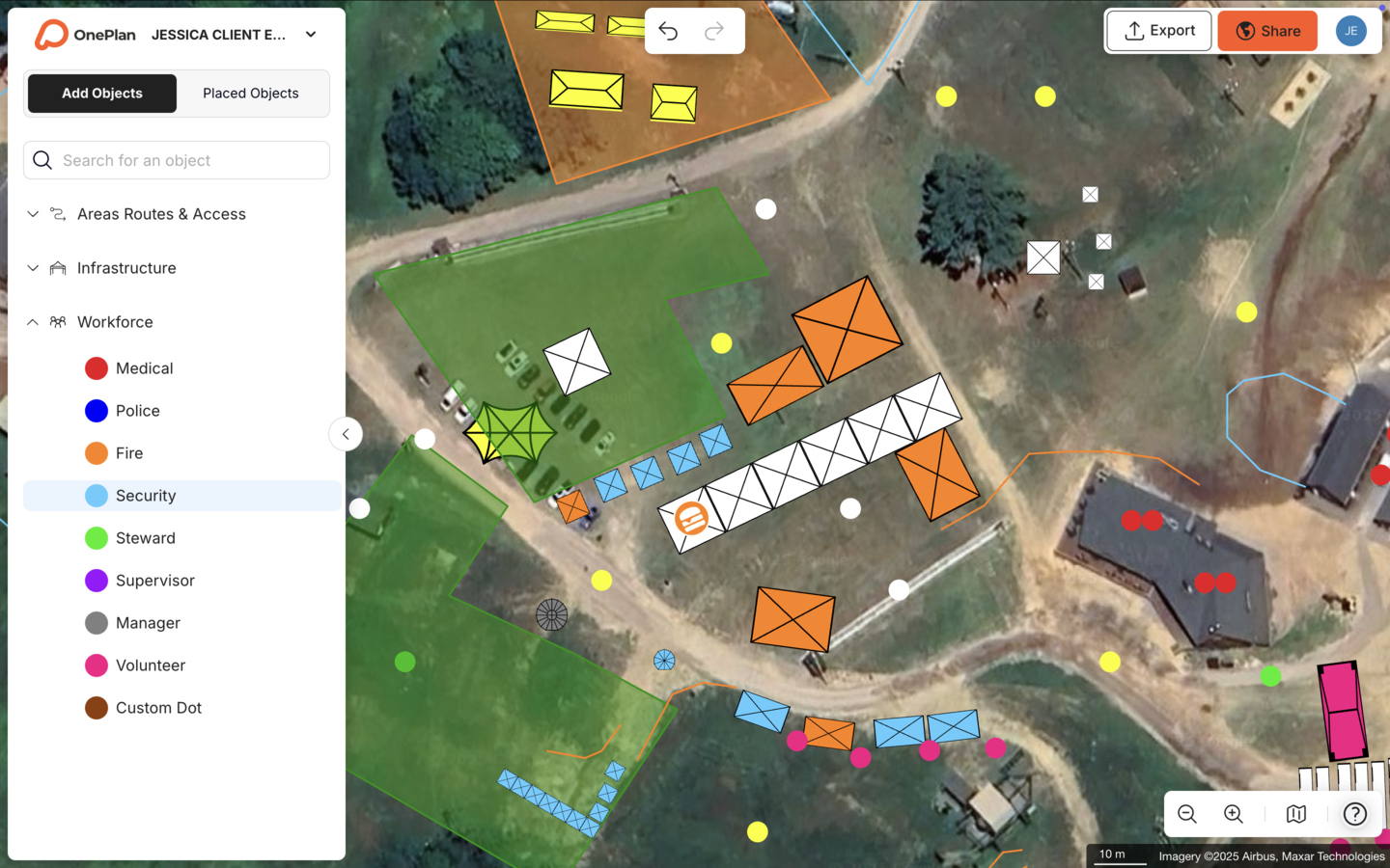
After you document your command structure, place command posts and staff dots to scale on your shared OnePlan map so every agency sees exactly where leadership will stand on the ground.
Essential Parade Safety Measures
Ten essential safety measures form the backbone of any permit-ready parade plan.
- Establish a named Incident Commander with clear decision authority.
- Install inner and outer perimeters using barriers, cones, and officers to separate spectators from the route.
- Deploy trained marshals with high-visibility vests and two-way radios at every corner and high-density intersection.
- Designate dedicated emergency access lanes along the full route length.
- Station first-aid posts and at least one ambulance at strategic intervals.
- Implement a vehicle inspection and driver briefing protocol before lineup.
- Set up a lost-persons station with a named, cleared staff member.
- Create a severe weather monitoring and decision protocol with named authority.
- Define show-stop criteria and communicate them to all agencies in advance.
- Conduct a pre-event walkthrough and post-event debrief with all key personnel.
Add barriers, stewards, and crossing points directly on your OnePlan map so every stakeholder sees the complete safety picture in one place.
Crowd Management and Barrier Layout
A 2026 systematic review found that multi-modal crowd management strategies combining environmental design, operational controls, real-time monitoring, and trained personnel were consistently associated with improved crowd-flow indicators and shorter evacuation times. For parade organizers, that finding means barrier placement, steward assignments, and crossing points need precise documentation, not rough estimates.
Effective crowd management for parades brings several elements together into one coordinated system:
- Continuous barrier lines along both sides of the route, with no gaps wider than a designated crossing point, to keep spectators separated from moving vehicles.
- Stewards positioned at every intersection, corner, and high-density spectator zone, so potential pressure points always have trained oversight.
- Designated pedestrian crossing points with marshals and clear signage, which give spectators safe, predictable ways to move between sides of the route.
- One-way spectator flow where route geometry allows, which reduces counter-flow congestion and speeds up movement at peak times.
- Standing capacity calculations for all enclosed spectator areas, using OnePlan’s crowd capacity calculator to outline any zone and instantly see its safe standing capacity.
For arrival and exit flow planning, use OnePlan’s free arrival calculator and exit calculator to estimate queue lengths and exit capacity before event day.
Draw barrier lines in OnePlan to auto-generate quantities in the Bill of Quantities, so you know exactly how many barrier segments to order before procurement begins.
Parade Route Planning Details
Route planning exposes the limits of static documents most clearly. A route that looks manageable on a screenshot may include a tight corner that a 40-foot float cannot navigate or an emergency access lane that disappears at a key intersection. Arsenal FC’s 2024 Premier League victory parade drew an estimated 750,000 to 1,000,000 attendees, far exceeding early predictions of around 500,000, which shows how manual planning based on initial estimates can quickly become inadequate.
A complete route plan documents related details that work together to keep the procession moving and emergency access open:
- Route segmented by block, with each segment assigned a marshal team and radio channel, so responsibilities stay clear.
- Emergency access lanes maintained at a minimum clear width throughout, with requirements confirmed with your local fire authority, such as those in the California Fire Code.
- Staging area dimensions and lineup sequence, which prevent congestion before step-off.
- Disbanding zone location and pedestrian dispersal plan, so crowds leave the area safely and predictably.
- Road closure schedule with times and responsible agency for each closure point, which coordinates traffic management with the route plan.
Import your route PDF as a .png base layer into OnePlan, scale it onto the satellite map, and plan on top of it. Every object you place stays to scale as you zoom.
Float and Vehicle Safety Rules
Float and vehicle incidents present a known risk at parades. La Verne, California’s 2026 Fourth of July Parade rules prohibit anyone from jumping on or off vehicles or floats at any time and require mandatory safety meetings with police department briefings for each entry group. Rules vary significantly by city and state, so always confirm requirements with your local permitting authority.
A standard float and vehicle section of a parade safety plan brings together driver controls, equipment standards, and contingency procedures:
- Driver licensing and minimum age requirements, which set a baseline for competence.
- Pre-parade mechanical inspection checklist, signed by a designated inspector, to catch issues before lineup.
- Fire extinguisher requirement on every motorized float, with type and rating confirmed with your local fire authority.
- Prohibited actions, such as throwing items to spectators, gaps in formation, and unauthorized stops, which reduce unpredictable movement.
- Turning radius rehearsal requirement for large floats, with marshals assigned to guide drivers at tight corners.
- On-site mechanic and breakdown protocol, so stalled vehicles do not block the route or emergency access.
Place floats and vehicles to scale on your OnePlan map and assign staff dots to each unit so marshals know exactly which team covers which entry.
Emergency and Evacuation Procedures
For parades, the emergency and evacuation section also needs to address route-specific actions and public movement:
- Show-stop signal and communication method, such as a radio call, PA announcement, or air horn pattern.
- Evacuation direction for spectators at each route segment, so stewards give consistent instructions.
- Rendezvous points for parade participants and staff, located away from the route.
- First-aid post locations with GPS coordinates or What3Words references.
- Named medical authority and EMS staging area.
- Lockdown or shelter-in-place protocol for incidents where evacuation is not appropriate.
Map evacuation routes and run standing capacity calculations in OnePlan so every agency reviews the same, up-to-date emergency picture.
Severe Weather Planning for Parades
Weather frequently forces parade modifications or cancellations. ASU’s Events Emergency Planning guide requires continuous monitoring of temperature, wind, and storm warnings for outdoor events and recommends designating one person with authority to decide on cancellation, postponement, or relocation to pre-established alternative locations.
A complete severe weather section documents clear roles, thresholds, and communication steps:
- Named weather monitor and monitoring tool or service.
- Specific thresholds that trigger review, modification, or cancellation, such as lightning within a defined radius or sustained wind speed, confirmed with your local emergency management office.
- Named decision authority and decision timeline relative to event start.
- Shelter locations for participants and spectators at each route segment.
- Public communication method for weather-related changes.
- Heat management provisions, including water distribution points, shaded rest areas, and medical guidance for heat-related illness.
Add weather-contingency shelter locations as points of interest on your OnePlan map and share the live plan with all agencies so every team sees the same contingency picture in real time.
Lost Children and Missing-Person Protocol
A complete lost-persons section covers clear locations, roles, and steps:
- Designated lost-persons station location, clearly marked on the site map.
- Named, cleared staff member assigned to the station for the full event duration.
- Discreet radio code for reporting a lost child without alarming spectators.
- Reunification steps, including identification process, documentation method, and parent or guardian notification procedure.
- Coordination protocol with police if reunification is not achieved within a defined timeframe.
Mark the lost-persons station and staff patrol routes on your OnePlan map so every marshal knows the exact location without consulting a separate document.
Communication Planning and Post-Event Review
A communication plan assigns a radio channel to every agency and function, defines backup methods, and names a single point of contact with venue or route management. Event security experts recommend using a shared radio channel, conducting 30-minute check-ins, implementing code words for escalation, and designating a single point of contact with venue management.
The post-event review section captures what happened and what should change next time:
- Incident log with time, location, type, and resolution for every recorded incident.
- Near-miss report and corrective actions.
- Staff and agency debrief notes.
- Template update items for the next edition of the plan.
“Working with the City of Lewisville’s Health and Safety Department was much simpler thanks to OnePlan. Being able to share detailed plans for roadblocks, crowd control, and traffic management meant we got the necessary approvals quickly and without headaches.” — Evelin Costa, North Texas Tribute Jam.
Export the Bill of Quantities and high-resolution maps directly from OnePlan for your permit file, contractor coordination, and post-event documentation.
Turning Your Template into a Live Map-Based Plan
A filled-in Word document or PDF gives you a starting point. A to-scale, collaborative map gives you a living plan that every agency can access, review, and act on. OnePlan is the visual, map-based platform that turns your 15-section template into that shared operational picture.

Here is how the workflow runs in OnePlan:
- Import your route: Convert your route PDF or image to .png, import it into OnePlan, and scale it onto the satellite or street map. Your real-world route becomes the base layer you plan on top of.
- Place to-scale objects: Drag and drop crowd barriers, first-aid tents, command posts, staff dots, vehicle positions, and points of interest, all to scale, directly onto the map.
- Run capacity calculations: Outline any spectator zone and OnePlan instantly returns its safe standing capacity. Use the area calculator to confirm emergency access lane widths and staging area dimensions.
- Generate a Bill of Quantities: Every object placed on the map feeds the auto-generated Bill of Quantities. Draw a barrier line and OnePlan tells you exactly how many segments to order.
- Collaborate in real time: Police, fire, traffic, and operations teams all work in the same live plan at the same time. Emailed PDFs and version confusion drop away.
- Export for permits: Export high-resolution maps, up to A0 and print-ready, plus a CSV inventory for your permit submission and contractor coordination.
Eagle Mountain City’s Events Manager Dawn Hancock reduced planning time from 8–10 hours to a few hours per event by creating one comprehensive map instead of separate layouts for fire, police, facilities, and other departments, achieving a 5x ROI. “Gone are the days of creating separate layouts for fire, police, facilities, and other departments. Now I can create a single, all-encompassing layout.”
“Everything was set up perfectly on race day as it was in OnePlan. Doing it in OnePlan means I don’t have to redo everything and can duplicate the plan.” — Ehrabi Nael, Race Director, Beirut Marathon.
OnePlan has powered 200,000 events in 150 countries, from community parades to the Paris 2024 Olympic Games. Your first event is free, with no payment details required.
Frequently Asked Questions
Can I customize this parade safety plan template for my city’s specific permit requirements?
Yes. The 15-section structure above provides a starting framework. Most U.S. cities and counties have their own permit application requirements that specify which sections, diagrams, and supporting documents must be included. Start with this template, then cross-reference your local permitting authority’s checklist and add or rename sections as needed. In OnePlan, you can build a reusable base plan for your parade route and update it each year without starting from scratch, which saves significant time across repeated annual events.
What maps or diagrams do permitting authorities typically require with a parade safety plan?
Most permitting authorities, including police and fire departments, require at minimum a to-scale route map showing road closures, barrier lines, emergency access lanes, first-aid post locations, command post positions, and staging and disbanding areas. Some jurisdictions also require a separate traffic management diagram and a crowd management plan with spectator zone layouts. Requirements vary by city and state, so confirm with your local authority. OnePlan exports high-resolution maps suitable for permit submission directly from the platform, and the Bill of Quantities provides the supporting inventory list many authorities also request.
How do I handle weather contingencies in a parade safety plan?
A weather contingency plan should name a single decision authority, define the specific thresholds that trigger a review or cancellation, such as lightning within a defined radius or sustained wind speeds above a set level confirmed with your local emergency management office, identify shelter locations for participants and spectators at each route segment, and document the public communication method for announcing changes. The plan should be shared with all agencies before the event so every team knows the protocol without waiting for a phone call. In OnePlan, shelter locations and contingency points of interest can be added to the same map as your primary plan, which gives every stakeholder a single reference document for both normal operations and weather scenarios.
What is the difference between an inner and outer perimeter in a parade safety plan?
An outer perimeter manages detoured vehicle traffic and keeps unauthorized vehicles away from the event footprint, typically using traffic cones, barrels, and officers at key intersections. An inner perimeter physically separates spectators from the parade route and participants, using crowd barriers, fencing, or portable cement barricades. The inner perimeter also incorporates designated crossing points with marshals so spectators can move between sides of the route safely. Both perimeters should be documented on your site map with barrier types, lengths, and assigned personnel. OnePlan’s Bill of Quantities automatically calculates how many barrier segments you need based on the lines you draw on the map.
How should a lost-child protocol be communicated to parade staff without alarming spectators?
The most effective approach uses a discreet radio code, a pre-agreed phrase or number that signals a lost-child situation to all staff without making a public announcement. Staff then direct the child to the designated lost-persons station, where a named, cleared staff member takes responsibility for supervision and documentation. The reunification process should follow a defined identification protocol before releasing the child to any adult. If reunification is not achieved within a set timeframe, the protocol should escalate to police. All staff and volunteers should be briefed on the code and the station location during the pre-event briefing, and the station should be clearly marked on the event map so every team member can direct a lost child there without hesitation.
How does OnePlan help reduce the number of site visits needed to finalize a parade safety plan?
Because OnePlan’s base layer is a live, zoomable satellite or street map built on leading GIS technology, planners can measure distances, confirm emergency access lane widths, calculate spectator zone capacities, and position infrastructure accurately from the office. That accuracy reduces the need to drive the route repeatedly. The Beirut Marathon cut approximately 20 pre-event site visits per year down to just one or two after adopting OnePlan. For parade organizers managing long routes across multiple city blocks, that reduction in site visits translates directly into saved staff time, fuel costs, and faster plan finalization ahead of permit deadlines.
Start Building Your Parade Safety Plan Today
A parade safety plan that satisfies police, fire, and permitting authorities functions as a living, map-based plan that every agency can access, verify, and act on. The 15-section template above gives you the structure, and OnePlan gives you the platform to bring it to scale.
Import your route, place barriers and staff to scale, run standing capacity calculations, generate a Bill of Quantities, and export permit-ready maps, all in one browser-based platform with no engineering background required. Get started today, with no payment details needed.