
Written by: Paul Foster, Founder, CEO, OnePlan
Key Takeaways for Collaborative Event Planning
- Collaborative event planning platforms support real-time multi-user editing, but only map-based tools provide to-scale spatial accuracy on live satellite or street maps.
- Task-management tools like Asana and monday.com handle checklists and timelines well yet lack any geo-accurate map layer, so teams fall back on static screenshots and version chaos.
- All-in-one platforms such as Cvent and Whova manage registration and attendee engagement effectively, but they do not solve the operational challenge of placing infrastructure accurately on an outdoor site.
- Visual mapping platforms are the only category that answers whether a layout actually fits by combining live maps, real-time collaboration, and auto-generated Bill of Quantities exports.
- OnePlan stands out as a purpose-built solution for event site planning, helping teams cut planning time and remove version chaos.
Quick Comparison: 2026's Leading Platforms
The table below compares how each platform performs across four core capabilities for collaborative site planning: real-time editing, spatial accuracy, inventory exports, and stakeholder permissions. Only OnePlan delivers all four on a live, geo-accurate map.
| Platform | Real-time multi-user editing | To-scale spatial accuracy on live map | Auto-generated Bill of Quantities / inventory export | Role-based permissions for external stakeholders |
|---|---|---|---|---|
| OnePlan | ✅ Yes | ✅ Yes, geo-accurate, GIS-powered live map | ✅ Yes, auto-generated, exports to Excel/CSV | ✅ Yes, Owner, Admin, Member; editable or view-only |
| Asana | ✅ Yes | ❌ No spatial/map layer | ❌ No, task exports only | ⚠️ Partial, guest access, no spatial permissions |
| monday.com | ✅ Yes | ❌ No spatial/map layer | ❌ No, board exports only | ⚠️ Partial, guest access, no spatial permissions |
| Cvent | ✅ Yes | ❌ No to-scale site mapping | ⚠️ Partial, registration/budget reports | ✅ Yes, role-based access |
| Whova | ✅ Yes | ❌ No to-scale site mapping | ❌ No | ⚠️ Partial, organizer/attendee roles |
| Social Tables | ✅ Yes | ⚠️ Partial, indoor floor plans, not geo-accurate outdoor maps | ⚠️ Partial, seating/room exports | ⚠️ Partial, venue and planner roles |
Task-Management Tools for Event Teams
Task-management platforms dominate search results for “event planning software,” yet they were built for project coordination, not spatial site design. They excel at checklists, timelines, and team communication, but they cannot place a tent to scale on a satellite map.
Asana
Asana offers real-time multi-user editing across boards, timelines, and calendars. Teams assign tasks, set deadlines, and track progress collaboratively. For event planners, it handles run-of-show logistics and vendor follow-ups well.
- Real-time multi-user editing: Yes
- To-scale spatial accuracy: No, there is no map layer, so site layouts cannot be drawn or measured
- Bill of Quantities export: No, task and project exports only
- Role-based external permissions: Partial, guest access is available but not tied to spatial views or site-plan layers
Asana works well alongside a site-planning tool, but it cannot replace one. Planners who rely on it for layout work still end up emailing static screenshots, which creates the version chaos that causes problems on event day.
monday.com
monday Work Management delivers visual boards, status columns, and color indicators that give immediate visibility into event progress. G2 review patterns show that changes made in one place reflect instantly across connected boards, reducing lag between insight and action for fast-moving events. One user noted, “Switching from Microsoft Excel, I appreciate the much more organized format that monday Work Management offers.”
- Real-time multi-user editing: Yes
- To-scale spatial accuracy: No, no geo-accurate map canvas
- Bill of Quantities export: No, board and item exports only
- Role-based external permissions: Partial, guest access without spatial context
monday.com suits teams managing diverse event types and high-volume programs. Its flexibility supports teams without rigid templates, though organizations seeking narrowly scoped tools may find the open-ended structure more demanding as complexity grows. Like Asana, it still leaves the spatial problem unsolved.
All-in-One Event Platforms for Attendee Experience
All-in-one platforms bundle registration, ticketing, attendee management, and sometimes floor-plan tools into a single product. They serve the attendee-facing side of events well. The operational, behind-the-scenes site plan is a different challenge that even comprehensive all-in-one platforms struggle to solve.
Cvent
Cvent is a comprehensive enterprise platform covering registration, venue sourcing, attendee engagement, and reporting. Its feature depth supports standardization and compliance for high-stakes enterprise events, though it introduces a learning curve for newer or less technical teams.
- Real-time multi-user editing: Yes
- To-scale spatial accuracy: No, no geo-accurate outdoor site-mapping layer
- Bill of Quantities export: Partial, registration and budget reports, not infrastructure inventory
- Role-based external permissions: Yes, role-based access across the platform
Cvent is the right tool for managing registrations and attendee data at scale. It is not designed to tell a site manager whether a 40-foot stage fits in a specific field or how many crowd barriers a particular zone requires, which leaves a critical gap for operations teams.
Whova
Whova focuses on attendee engagement, including agendas, networking, exhibitor management, and event apps. It is widely used for conferences and expos where the attendee experience is the primary deliverable.
- Real-time multi-user editing: Yes
- To-scale spatial accuracy: No, no site-mapping capability
- Bill of Quantities export: No
- Role-based external permissions: Partial, organizer and attendee roles, not spatial-layer permissions
Whova and Cvent both leave the physical site plan to other tools, which for most teams means PowerPoint, Excel, Canva, Photoshop, Google Maps, or internal static screenshots. That gap often becomes the starting point for version chaos.
Visual and To-Scale Mapping Platforms
This category tackles the core spatial problem directly: placing infrastructure accurately on a real map, collaborating on it in real time, and exporting a usable inventory. Only platforms in this category can reliably confirm whether a layout will fit.
Social Tables
Social Tables (now part of Cvent) provides collaborative diagramming for indoor venue spaces such as banquet rooms, conference halls, and ballrooms. Multiple users can edit floor plans simultaneously, and the tool is well-regarded in the hospitality sector for seating and room layouts.
- Real-time multi-user editing: Yes
- To-scale spatial accuracy: Partial, accurate for indoor floor plans, but not geo-accurate outdoor site maps
- Bill of Quantities export: Partial, seating and room configuration exports
- Role-based external permissions: Partial, venue and planner roles
Social Tables is purpose-built for indoor hospitality events. It does not extend to outdoor festivals, road events, multi-venue operations, or the infrastructure-heavy site planning that operations and safety teams require.
OnePlan
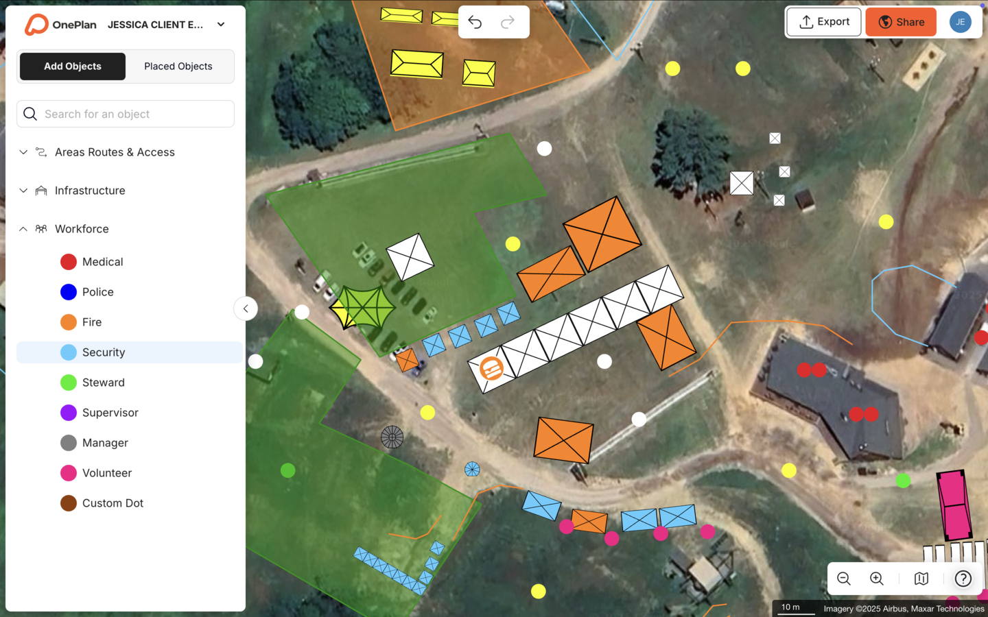
OnePlan is a visual, to-scale platform built specifically for event site and venue planning. Its base layer is a live, zoomable satellite or street map, not a blank canvas, so every object placed on it stays geo-accurate at any zoom level. From a 10×10 ft tent to miles of crowd barriers, everything remains to scale, measurable, and shareable in real time.
See how OnePlan eliminates version chaos by scheduling a quick walkthrough of the platform.
OnePlan has powered 200,000 events in 150 countries, from community fairs and county festivals to Formula 1 circuits and the Paris 2024 Olympic Games. The platform's 2026 Event Site Planning Report found that 71% of event professionals rank attendee safety and security as their top priority, and 44% say accurate measurements and layouts are critical to success. Yet inaccurate plans still appear frequently across the industry.

Customer results highlight the impact of accurate, collaborative mapping:
- Silverstone achieved a 13x ROI, a 10% reduction in planning days, and a further 5% in supplier efficiencies across the Formula 1 British Grand Prix and 50+ events a year. “For us, OnePlan is that single source of truth, it's always up-to-date and allows for instant collaboration, especially in our case with suppliers.”
- The Tour of Britain reduced site visits by 75%, saved 300+ hours per year, and achieved a 3x ROI across its 8-stage, 1,352 km national race.
- SoulFest cut planning time by 85%, building almost its entire festival map in two days.
- Eagle Mountain City reduced planning from 8–10 hours to a few hours per event and reported a 5x ROI. “Gone are the days of creating separate layouts for fire, police, facilities, and other departments. Now I can create a single, all-encompassing layout.”
- Columbus Crew saved 40% of planning time by bringing team members, contractors, first responders, and operations staff into one shared plan. “We can plan faster, collaborate better, and make decisions in the same meeting.”
These time savings stem directly from OnePlan's automation and collaboration features. The auto-generated Bill of Quantities turns every object on the map into an exportable inventory, so drawing a line of crowd barriers instantly reveals how many segments to order and removes hours of manual counting. That inventory stays current because role-based permissions (Owner, Admin, Member, editable or view-only) and secure, password-protectable share links ensure every external stakeholder sees the latest version without anyone resending files.
Small-Team Pain Points: Version Chaos and Spreadsheet Overload
Event planners across forums and communities describe the same frustrations: “I've got five versions of the site plan and I don't know which one is current.” “Our security team is working off a map from three weeks ago.” “I spent two days measuring the field by hand and the tent still didn't fit.”
These situations are common rather than rare. Special Olympics Virginia described working in silos with low visibility across departments, with every team using different tools, including Photoshop, Illustrator, and InDesign, then moving from days of measuring and mapping by hand to just hours on OnePlan.
The Jockey Club previously planned events with aerial screenshots dropped into PowerPoint, drawing red and white lines over them by hand. Today, the team calls OnePlan “one single live masterplan, we treat it as the gospel of truth.”
OnePlan resolves version chaos by making one live plan the only plan. Real-time collaboration lets the whole team edit simultaneously, and secure share links ensure stakeholders always see the latest version. The Bill of Quantities removes the spreadsheet-and-email loop for procurement, and the live map base layer keeps layouts accurate before anyone sets foot on site.
Decision Framework for Choosing a Platform
Use the prompts below to match your needs to the right category of tool.
What type of event are you planning? If it involves a physical site such as a festival field, road race route, stadium precinct, or park, you need a spatial mapping tool rather than a task manager. If your primary deliverable is attendee registration, ticketing, or conference scheduling, an all-in-one platform may be sufficient for the attendee-facing layer.
How large is your team, and how many external stakeholders need access? Small teams with a handful of internal users can manage with simpler tools. As soon as police, fire, medical, vendors, contractors, or local authorities need to see or edit the plan, role-based permissions and a single source of truth become essential. OnePlan's Team plan starts from 3 users and supports unlimited event creation with collaboration features built in.
Is your planning primarily attendee-facing or behind-the-scenes operational? Attendee-facing needs such as apps, agendas, and networking point toward Cvent or Whova. Behind-the-scenes operational needs such as site layout, infrastructure placement, crowd flow, traffic management, and permitting point toward OnePlan. Many organizations use both, pairing an all-in-one platform for the attendee experience with OnePlan for the site plan.
Do you run recurring events or manage multiple venues? OnePlan's reusable templates and multi-event structure mean you build once and reuse year after year. The Tour of Britain's plans are ready six months in advance and remain a “living thing” until race day, updated in real time rather than replaced with a new static file each year.
What's your budget? OnePlan offers a free first event tier, which covers up to 25 objects with no payment details required. Paid plans start from around $75 per month per seat, and annual billing typically saves about 20%. CAD software and enterprise platforms like Cvent usually carry higher costs and steeper learning curves, so OnePlan often delivers stronger value for operational planning.
Frequently Asked Questions
What is a collaborative event planning platform?
A collaborative event planning platform is software that lets multiple team members and stakeholders work on the same event plan simultaneously. The most capable platforms combine real-time editing with spatial, map-based planning, so operations, security, vendors, and authorities all work from one live, accurate site plan rather than separate files. OnePlan is built specifically for this, as a browser-based platform where anyone can drag and drop to-scale infrastructure onto a live satellite or street map and share it with every stakeholder in real time.
Does OnePlan work for both indoor and outdoor events?
Yes. OnePlan handles outdoor sites such as festival fields, road race routes, stadium precincts, and parks, along with indoor spaces, including multi-level venues where you toggle between floors. The platform focuses on operational and spatial planning, covering where infrastructure, staff, and crowds go. It is not a 3D interior visualizer or banquet-décor tool.
Can I use OnePlan for a one-off event, or is it only for recurring events?
OnePlan works for both one-off and recurring events. Your first event is free, and after that you can pay month-to-month for just the period you need, then stop. There is no requirement to commit to an annual plan. Teams running recurring events gain extra value because plans become reusable templates, so they build once, refine each year, and save hours every cycle.
Can I import my existing CAD files, floor plans, or Google Maps screenshots into OnePlan?
Yes. Convert your existing PDFs, images, CAD-derived files, drone photos, or floor plans to .png format first, then import them into OnePlan, scale them onto the map, and plan on top of them. Files that previously sat unused in a folder become reusable base maps you can build on every year. OnePlan also integrates with Google Satellite and Mapbox as live base layers, so your plan always sits on current, geo-accurate imagery.
How does OnePlan handle pricing for small teams and one-off organizers?
The free tier mentioned earlier requires no payment details and lets you plan on a live map with a limited object count. After that, the Pro plan suits individual planners managing up to 10 events with advanced features. The Team plan starts from 3 users and supports unlimited event creation with full collaboration features. Annual billing saves approximately 20% versus monthly. There is no enterprise-only pricing wall, so OnePlan remains accessible to both community fair organizers and Formula 1 venues.
What makes OnePlan different from task-management tools like Asana or monday.com?
Task-management tools are excellent for checklists, timelines, and team communication, but they have no map layer. They cannot place a stage to scale in a field, calculate whether a crowd area is safe at peak capacity, or tell a procurement team how many crowd barriers to order. OnePlan does all of that on a live, geo-accurate map, with a drag-and-drop library of thousands of event-specific objects, intelligent crowd and traffic calculators, and an auto-generated Bill of Quantities. Many teams use both, pairing a task manager for run-of-show logistics with OnePlan for the site plan.
How accurate is OnePlan's mapping, and does it work anywhere in the world?
OnePlan is built on leading GIS mapping technology powered by Esri, the global GIS leader. Every object placed on the map stays geo-accurate and to scale at any zoom level. Place a 10×10 ft tent and it remains correct as you zoom, or outline a crowd area and OnePlan instantly returns its size and safe standing capacity. The platform has been used worldwide, from local community fairs to the Paris 2024 Olympic Games across 46 venues.