
Written by: Paul Foster, Founder, CEO, OnePlan
What Martyn’s Law Means For Marathon Route Planning
Martyn’s Law (Terrorism (Protection of Premises) Act 2025) turns marathon route planning into a formal security duty for UK race directors. Once a qualifying event meets the Enhanced Tier threshold, organizers must complete terrorism risk assessments, apply proportionate protective measures, and keep clear written records for the Security Industry Authority (SIA).
Understanding Martyn’s Law And Enhanced Tier Requirements
Martyn’s Law is named in tribute to Martyn Hett, one of the 22 victims of the 2017 Manchester Arena attack. The legislation establishes a two-tier framework based on the number of individuals reasonably expected to be present at the same time.
The Enhanced Tier applies to premises and qualifying events where 800 or more individuals are reasonably expected to be present at the same time. Major marathons, with massed starts, spectator zones, and transport hub convergence, usually meet this threshold. Mass participation events such as marathons may qualify if 800 or more people are reasonably expected to be present at the same time, even if only briefly. Staff, volunteers, and contractors count toward that total.
Enhanced Tier duty holders must fulfill the following obligations, so far as is reasonably practicable:
- Ensure appropriate public protection procedures are in place, covering evacuation, invacuation, lockdown, and communication
- Implement public protection measures to reduce vulnerability to terrorism and the risk of physical harm
- Document all procedures and measures, including an assessment of how they reduce vulnerability, and provide this to the SIA
- Designate a senior individual responsible for organizational compliance
- Notify the SIA when they become, and cease to be, the responsible person
The Security Industry Authority (SIA) is the designated regulator, with enforcement powers including compliance notices, monetary penalties, and restriction notices. Race directors should consult GOV.UK and ProtectUK for the latest official guidance.
Route Selection And Vulnerability Mapping
Route selection is the first major security decision a race director makes, and under Martyn’s Law it carries formal weight. Common vulnerability factors identified during site surveys include access and egress points, crowd flow pinch points, areas of elevated risk such as bars, backstage zones, car parks, and first aid posts, and communication dead spots. Choosing a route that reduces these risks from the outset lowers the mitigation burden later.
Practical route selection criteria include:
- Avoid narrow streets, tunnels, and bridges where crowd density is hard to control and emergency vehicle access is restricted
- Reduce the number of uncontrolled vehicle access points along the course
- Maintain good sightlines for security personnel and CCTV coverage
- Identify ingress and egress routes, queue design, search arrangements, and emergency egress calculations during a pre-event walk-through
Once a candidate route is identified, vulnerability mapping turns the physical environment into a documented risk picture. A practical Martyn’s Law planning approach starts with an accurate site or route map that includes every open space, access point, and service area. The next step divides the space into manageable zones for phased evacuation, with each zone having at least two independent exit routes.
OnePlan’s to-scale satellite map allows race directors to plot the full route and mark vulnerable points remotely before a single site visit. As Beirut Marathon Race Director Ehrabi Nael explains: “I can choose a location for a race that’s not even nearby and start planning everything, measuring everything in OnePlan and see if the layout I want is feasible or not before even doing a site visit.” The Beirut Marathon, which gathers 49,000 participants annually, cut required site visits by 75% using this approach. Once the route is mapped, the next step is to divide it into security zones based on crowd density and risk.
High-Density Security Zoning
Risk varies along a marathon route. The tier assessment under Martyn’s Law is based on the greatest number of individuals reasonably expected to be present at the same time at any point during the event. Start and finish areas, transport hubs, and major spectator zones usually define this peak and require the strongest controls.
Dividing the route into security zones based on crowd density and risk allows proportionate measures in each area. Enhanced Tier public protection measures must address four categories: monitoring the premises or event and their immediate vicinity, controlling movement of individuals, physical safety and security, and security of information.
| Event Zone | Risk Level | Required Measures |
|---|---|---|
| Start/Finish Area | High | Vehicle mitigation barriers, bag checks, stewarding, CCTV |
| Transport Hubs | High | Increased patrols, CCTV monitoring, coordination with transport authorities |
| Open Course (Miles 2–25) | Medium | Regular steward presence, clear signage, mobile patrols |
| Dispersal Areas | Medium | Crowd flow management, exit route signage, steward direction |
OnePlan enables race directors to create separate layers for each zone and place barriers, checkpoints, and steward positions as to-scale objects on a live satellite map. This visual, layered approach makes it straightforward to communicate security plans to Safety Advisory Groups, police, and other stakeholders. Everyone works from the same live plan rather than separate documents. With zones defined, the next priority is ensuring emergency vehicles can reach every part of the course.
Emergency Access And Incident Response Planning
Clear, unobstructed emergency vehicle access is a non-negotiable element of marathon route planning. Emergency services always retain the right to access any part of a closed course, and cones and route controls are managed in real time so emergency vehicles can pass without delay.
Key elements of emergency access planning include:
- Blue light lanes: Emergency access routes must appear on the site plan as fixed, named routes, not implied gaps between other infrastructure, and must remain clear and passable throughout the event.
- Incident command points: Named points of contact and incident reporting arrangements should be recorded so the security plan is operationally usable.
- Evacuation assembly areas: Assembly areas must be capable of holding the crowd, with a public address system or reliable alternative for giving instructions.
- Medical facility access: At least one side of the main medical facility must be directly accessible to ambulances without requiring those vehicles to navigate through crowd areas.
- Rolling closure coordination: A traffic management plan should include pre-identified emergency access corridors for first responders, with every vehicle crossing point assigned a plan, staffing, and communication method.
OnePlan’s traffic management tools allow race directors to plan road closures and vehicle access routes to scale, calculate distances and access times, and export high-resolution maps for Safety Advisory Group meetings. The Tour of Britain used OnePlan to have plans ready six months in advance as a “living” plan until race day. The same approach keeps emergency access documentation current and shareable as the event evolves.
Crowd Movement And Spectator Safety
Safe crowd movement along the route, especially at start and finish areas, transport hubs, and spectator pinch points, is both a safety obligation and an Enhanced Tier requirement. Crowd-management guidance recommends calculating the maximum safe occupancy for every zone of the event, not just the overall venue, and creating buffer zones between high-density and moderate-density areas so that crowd pressure in one zone does not cascade into adjacent spaces.
OnePlan’s crowd capacity calculator lets race directors outline any spectator area and instantly see its standing capacity based on a selectable density setting. This produces defensible figures for Safety Advisory Group sign-off. For ingress and egress planning, OnePlan’s free arrival calculator and exit calculator estimate queue times and exit capacity, helping race directors identify bottlenecks before event day.
As Ehrabi Nael of the Beirut Marathon notes: “One of the features I like most right now is the crowd measurement feature. It’s so helpful to measure how many people you’re going to fit in a small area.” Because capacity requirements vary by region, readers should consult their local Safety Advisory Group and relevant authorities for specific figures.
Communication And Training Across The Route
Communication is a standalone requirement under Martyn’s Law and must use multiple channels, including audio announcements, digital signage, and staff-led guidance, with two-way flow so staff can report back to coordinators. For a marathon, this means PA systems at start and finish areas, radio coverage across the full course, and clear briefing protocols for stewards at every zone.
OnePlan allows race directors to assign steward positions and roles directly on the map, with shift times, notes, and equipment recorded in the back-end dashboard. Real-time collaboration means operations, security, medical, and stewarding leads work from the same live plan, which removes the version-control problems of emailed PDFs. As the Sydney Harbour 10k team found: “The collaborative element of OnePlan is great. It allows for greater team collaboration. OnePlan streamlines our process in a way that we hadn’t realised was possible before.”
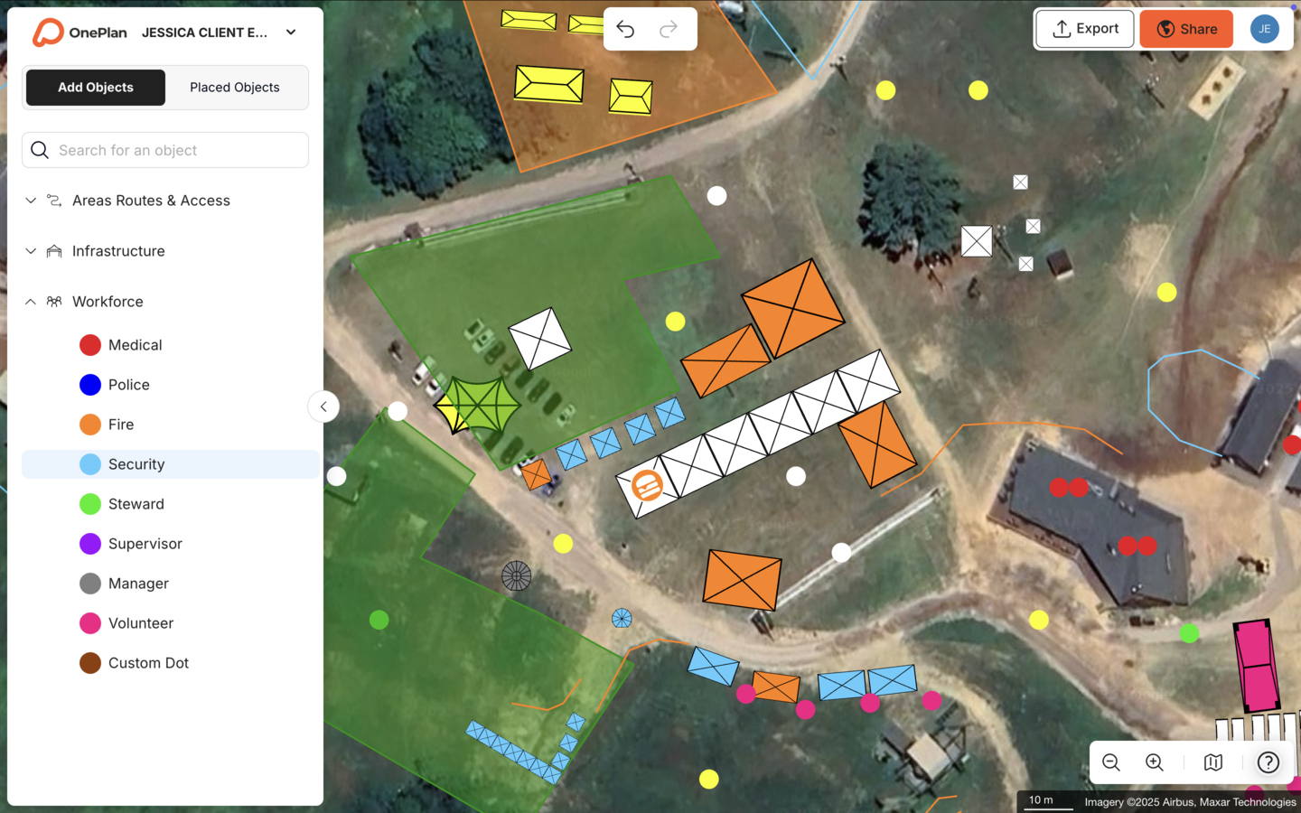
Using A Layered Map For Martyn’s Law Compliance
Documentation is the defining challenge of Martyn’s Law compliance for marathon organizers. The SIA requires a written record of all procedures and measures, including an assessment of how they reduce vulnerability. A layered, map-based plan provides an efficient way to produce and maintain that record.
OnePlan enables race directors to build a multi-layered security plan on a live satellite map. Separate layers cover the route, security zones, emergency access, crowd flow, and steward positions. Drag-and-drop to-scale objects, such as barriers, stewards, vehicles, and signage, are placed directly onto the map. The auto-generated Bill of Quantities turns every object into an exportable inventory, so procurement and documentation happen at the same time. Plans export to high-resolution PNG for permit submissions and Safety Advisory Group presentations.
The Tour of Britain saved 300+ hours per year and achieved a 3x ROI by coordinating every stage of an 8-stage, 1,352 km national race in OnePlan. The same methodology applies directly to marathon route security planning under Martyn’s Law.
Conclusion And Next Steps For Race Directors
Martyn’s Law transforms marathon route planning from a logistical exercise into a documented security obligation. Race directors responsible for events expecting 800 or more participants must now conduct terrorism risk assessments, implement proportionate security measures across every zone of the route, and produce written documentation for the SIA. They must also coordinate police, fire, medical teams, and Safety Advisory Groups around a single, accurate plan.
A layered, to-scale, collaborative mapping platform offers a practical way to meet these obligations. OnePlan gives race directors tools to conduct vulnerability assessments, design security zones, plan emergency access, calculate crowd capacities, and export professional documentation. All of this sits on one living plan that every stakeholder can access and act on.
For the latest legal requirements, consult the official statutory guidance at GOV.UK and the supporting resources at ProtectUK. To bring your Martyn’s Law planning together in one place, start with OnePlan.
Frequently Asked Questions
Does Martyn’s Law Apply To My Marathon?
Martyn’s Law applies to qualifying events where 800 or more individuals, including staff, volunteers, and contractors, are reasonably expected to be present at the same time at any point during the event. For most major marathons, half-marathons, and large-scale road running events, this threshold is met at the start area, finish area, or both. The event must also be accessible to the public and have measures in place to check entry conditions, such as race registration or bib collection. If your event takes place on open public land with no entry controls, it may fall outside the qualifying event definition, but you should verify this against the official statutory guidance and consult your Safety Advisory Group. Enforcement is expected no earlier than April 2027, so the implementation period is the right time to assess your obligations and begin planning.
What Documentation Does The SIA Require From Enhanced Tier Marathon Organizers?
Enhanced Tier duty holders must prepare a written document that records all public protection procedures and measures in place or proposed, including an assessment of how those measures reduce vulnerability to terrorism and the risk of physical harm. This document must be provided to the Security Industry Authority as soon as reasonably practicable after it is prepared, and resubmitted within 30 days of any revision. The document should cover evacuation, invacuation, lockdown, and communication procedures, as well as physical measures such as vehicle mitigation barriers, CCTV, bag search policies, and access controls. A to-scale, layered map produced in a platform like OnePlan, with an auto-generated Bill of Quantities and exportable high-resolution outputs, provides a strong foundation for this documentation and makes it straightforward to update as the plan evolves.
How Do I Conduct A Terrorism Vulnerability Assessment For A Marathon Route?
A terrorism vulnerability assessment for a marathon route examines the physical environment of the full course to identify points where an attack could cause the greatest harm and where existing controls are weakest. The assessment should consider the start and finish areas, transport hubs, spectator pinch points, vehicle access points, and any sections of the route with limited sightlines or restricted emergency access. For each identified vulnerability, the assessment should document the nature of the risk, the likelihood and potential impact of an attack, and the measures in place or proposed to reduce that risk. The National Protective Security Authority (NPSA) and ProtectUK publish guidance and resources to support this process. Conducting the assessment on a to-scale map, rather than from memory or a static PDF, makes it easier to identify gaps, communicate findings to stakeholders, and update the assessment as the route or security arrangements change.
How Should Emergency Vehicle Access Be Planned For A Closed-Road Marathon?
Emergency vehicle access must appear as a fixed, named element of the site plan, not as an implied gap between other infrastructure. Every section of the closed course should have a designated blue light lane or emergency access corridor that remains clear and passable throughout the event, regardless of spectator numbers or infrastructure placement. Traffic management plans should identify pre-agreed emergency access corridors, with every vehicle crossing point assigned a staffing plan and communication method so access can be managed quickly. Coordination with local police, fire, and ambulance services should happen early in the planning process, with emergency access routes shared with all relevant agencies before race day. Medical facilities should be positioned so that at least one side is directly accessible to ambulances without navigating through crowd areas. OnePlan’s traffic management tools allow these routes to be mapped to scale, with distances and access times calculated from the desk, and exported for Safety Advisory Group review.
Can OnePlan Help Produce The Security Documentation Required Under Martyn’s Law?
OnePlan is a planning and mapping tool, not a legal or regulatory authority, and race directors should always consult official guidance and their Safety Advisory Group for compliance requirements specific to their event. OnePlan is well suited to supporting the documentation process. The platform allows race directors to build a multi-layered, to-scale security plan covering the full route, security zones, emergency access corridors, steward positions, and crowd capacity calculations. The auto-generated Bill of Quantities exports every object on the map as a structured inventory. Plans export to high-resolution PNG for permit submissions and stakeholder presentations. Real-time collaboration keeps the plan current as security arrangements evolve, and the entire team, including operations, security, medical, and police liaison, works from the same single source of truth rather than separate documents. This approach makes it significantly easier to prepare, maintain, and resubmit the documentation the SIA requires.