
Written by: Paul Foster, Founder, CEO, OnePlan
Key Takeaways for Parade Route Mapping
- Traditional parade maps built in PowerPoint or static PDFs cause last-minute changes, inaccurate counts, and failed safety reviews.
- A repeatable five-step workflow with a live map base, to-scale objects, crowd modeling, Bill of Quantities, and permit-ready exports prevents these issues.
- Real-time collaboration and geo-accurate tools let every department work from a single, up-to-date plan without repeated site visits.
- Auto-generated inventories and high-resolution exports produce the exact counts and visuals needed for procurement and permitting.
- Book a 15-minute demo to see how OnePlan streamlines your 2026 parade route planning.
Why a To-Scale Parade Route Map Matters for 2026
A parade route map acts as the operational backbone for approvals, procurement decisions, and safety reviews. When the map is inaccurate or not drawn to scale, barrier counts are wrong, crowd pinch points go undetected, and road-closure orders cover the wrong streets.
Recent 2026 events show how complex real-world parade logistics can become. The 2026 Chicago Pride Parade followed a two-mile route with parking restrictions. The 2026 Calgary Stampede Parade featured phased road closures beginning at 6 a.m.. A mid-size city Christmas parade may be shorter, yet it still requires staging areas, dispersal points, barrier placements, and coordinated sign-off from public works, police, and fire, all of which depend on an accurate map.
Requirements vary by municipality and state, so confirm specifics with the relevant local authority. The constant factor is the need for a to-scale, shareable plan that every department can work from at the same time.
Step 1: Use a Live Map Base and Import Existing Route Files
Start by opening OnePlan and selecting your map base. Choose Google Satellite for a photographic overhead view of the actual streets, or Mapbox for a clean street-map layer. The canvas uses a live, zoomable map built on leading GIS technology, so every object placed on it stays geo-accurate at any zoom level. This creates a clear difference from a screenshot dropped into a presentation, because the geography reflects the real world instead of an approximation.

If your team already has a route sketch, a PDF from a previous year, or a CAD-derived file, convert it to PNG and import it as an overlay. Scale it onto the map and plan directly on top of it. Before using OnePlan, Pont3 created event plans by taking screenshots from Google Earth, inserting them into PowerPoint, and adding shapes that were not to scale. Importing existing files into OnePlan removes that guesswork and turns rough sketches into precise, geo-referenced plans.
Step 2: Draw the Parade Route with To-Scale Infrastructure
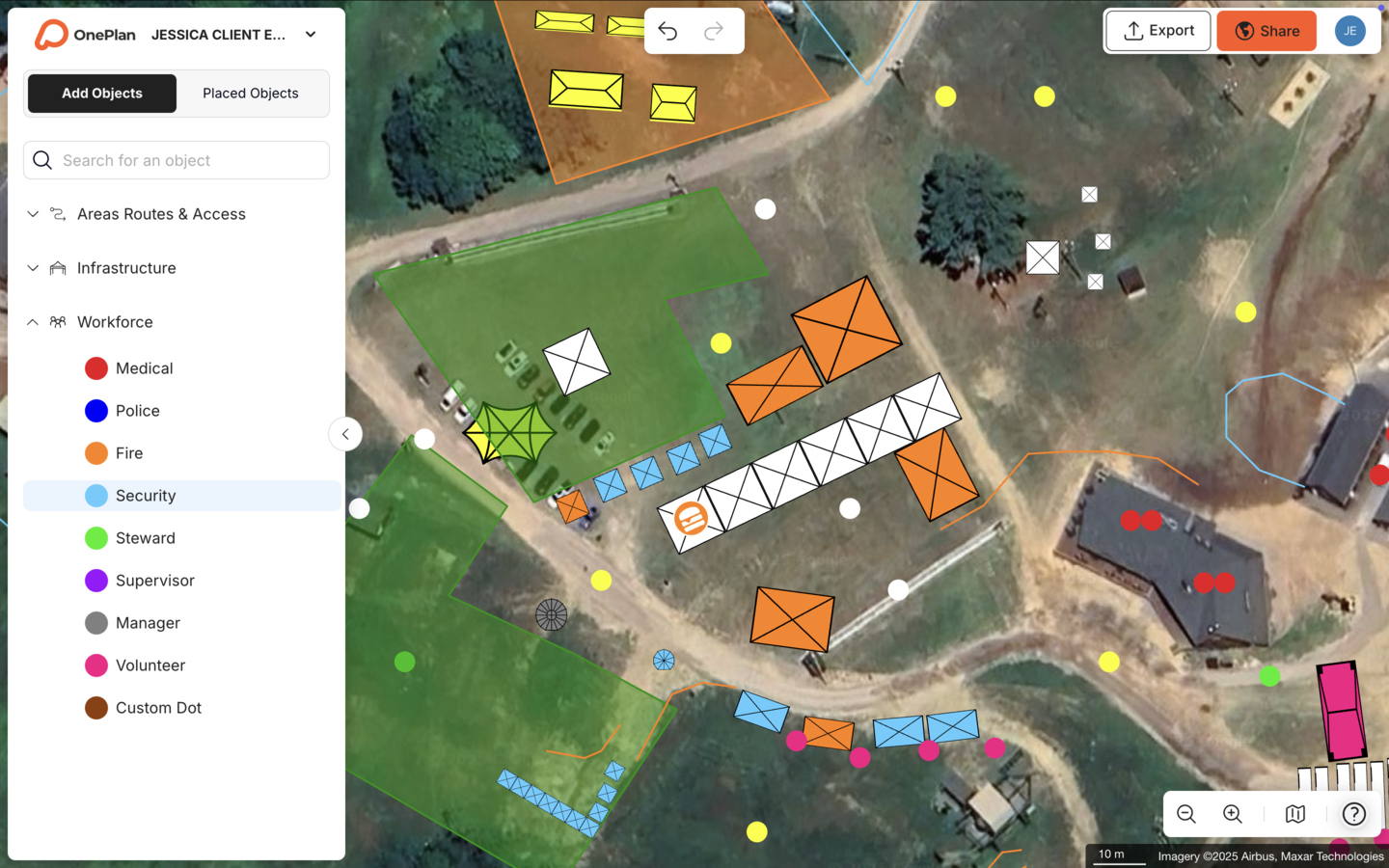
Next, draw the route line and begin placing infrastructure along it. OnePlan’s library contains thousands of drag-and-drop objects sized to real-world dimensions, including crowd barriers, cones, signage, portable toilets, first-aid stations, and generators. Because every object stays accurately to scale as you zoom, a barrier segment placed at its true length reflects exactly how much linear footage you are committing to, which removes the guesswork that comes from approximate shapes in presentation software.
Use points of interest, which appear as quick, recognizable icons, to mark entrances, exits, pedestrian crossings, road-closure points, and first-aid locations without over-building the map. Place workforce dots for police, stewards, medical staff, and traffic marshals along the route, then assign each a name, shift time, and notes. This produces a single map that operations, police, fire, and public works can all read without needing a separate briefing document.
Stadium planned Coventry Moves, an event with over 400 individual closures across seven procession routes and 110 stakeholders, entirely in OnePlan. The team reduced the time to create eight traffic management maps from a full day in CAD to about two hours.
Step 3: Model Crowd Capacity and Traffic Flow on the Map
After drawing the route, use OnePlan’s area and perimeter calculator to outline each spectator zone. The tool instantly returns the area in square feet so you know exactly how much space is available before committing to a layout. Then apply the crowd capacity calculator by drawing the standing crowd area so OnePlan can calculate how many people that zone can safely hold.
These calculations matter because crowd capacity on parade route segments must account for peak occupancy, flow rate in persons per minute per foot of effective width, and resulting density for each zone, and the figures need to be defensible before any permitting authority reviews them. OnePlan’s calculators produce those figures directly from the map, not from a separate spreadsheet.
For arrival and departure modeling, use OnePlan’s free arrival calculator to estimate queue length and wait time at ticket checks or security screening. Then use the exit calculator to estimate exit capacity based on exit width, crowd size, and flow rate. These tools highlight bottlenecks on the map before they appear on the street.
Step 4: Create a Bill of Quantities from Your Map
Every object placed on the OnePlan map saves automatically to a back-end inventory. When the route plan is complete, export the auto-generated Bill of Quantities as a CSV or Excel file. It lists every barrier segment, cone, sign, portable toilet, and staffing dot with exact counts, which gives you the precise figures needed for procurement orders and permit submissions.
The Tour of Britain achieved a 75% reduction in site visits and saved more than 300 hours per year using OnePlan, with the Bill of Quantities replacing the manual spreadsheet exchanges that previously consumed days of back-and-forth with suppliers. Parade planners can apply the same workflow by drawing the barrier line and letting OnePlan report exactly how many segments to order.
Step 5: Export High-Resolution Maps and CSV Inventories
Once the plan is complete and quantities are confirmed, export a high-resolution PNG map, which is print-ready up to A0, alongside the CSV inventory. These two files form the core of a permit packet. The map shows authorities exactly where every closure, barrier, and access point sits, and the inventory confirms the infrastructure counts that support it.
The same Pont3 team now produces centimeter-accurate, permit-ready plans without a CAD specialist. Share a live, view-only link with police, fire, and public-works reviewers so every stakeholder sees the latest version without anyone resending files.
Common Parade Planning Challenges and Fixes
Even experienced planners run into predictable problems when building a parade route map. Because these issues come up repeatedly across different events and municipalities, the list below highlights the most common ones along with a practical fix for each.
- Version-control chaos. When the route map lives in an emailed PDF, different departments end up acting on different versions. OnePlan’s real-time collaboration keeps every stakeholder in the same live plan, so there is only one current version at any time. Eagle Mountain City eliminated the need to create separate maps for fire, police, facilities, and other departments by building one comprehensive, to-scale map shared across all of them, cutting planning time by 70%.
- Underestimated infrastructure. Barrier and signage counts based on a non-scaled map are almost always wrong. Draw objects at their true dimensions in OnePlan and let the Bill of Quantities produce accurate counts automatically. Bearfoot Productions used OnePlan to confidently order 8 km of fencing based on precise map measurements rather than estimates.
- Stakeholder misalignment. Planning in isolation results in misaligned timelines, conflicting priorities, and unrealistic dependencies. Sharing a live OnePlan link with police, fire, and public-works contacts before the permit submission, rather than after, surfaces conflicts early enough to resolve them without last-minute route changes.
- Repeated site visits. The Beirut Marathon reduced required site visits from 20 down to just one or two by measuring and planning remotely in OnePlan before finalizing details on the ground. Parade planners can follow the same approach by validating distances and layouts from the desk first, then confirming details on site.
- Non-scalable legacy files. Existing PDFs and old Google Earth screenshots cannot be built on directly. Convert them to PNG, import them into OnePlan, scale them onto the live map, and plan on top, which turns documents that used to sit unused in a folder into reusable base maps.
Frequently Asked Questions
How long does it take to build a parade route map in OnePlan?
Most planners can build a working parade route map in a single session. Because OnePlan is drag-and-drop and runs entirely in the browser with no installation required, you can sign up and start placing objects on a live satellite map within seconds. SoulFest, one of New England’s largest music festivals, built almost its entire site map within two days. A straightforward parade route with barriers, signage, and workforce placements typically takes a few hours from a blank map to an export-ready file, which is significantly less time than recreating the same plan across multiple tools.
Can multiple stakeholders edit the same plan at once?
Yes. OnePlan supports real-time collaboration, so multiple people can work in the same live plan simultaneously. Changes are visible immediately, which means your operations team, police liaison, and public-works contact can all contribute to the same parade route map without anyone overwriting someone else’s work or waiting for an emailed update. You can also share a secure, view-only link with reviewers who need to see the plan but not edit it.
Does OnePlan work for both indoor staging areas and outdoor routes?
Yes. OnePlan handles outdoor parade routes and indoor spaces, including multi-level venues where you can toggle between floors. For parade planning specifically, this means you can map the full outdoor route and also plan any indoor staging or assembly areas, such as a convention center pre-parade staging hall, within the same platform. OnePlan focuses on operational and spatial planning, such as where infrastructure, staff, and crowds go, rather than 3D interior visualization.
How do I scale from a one-block parade to a multi-mile course?
The workflow stays identical regardless of route length. OnePlan’s live map canvas zooms and pans like Google Maps, so you can plan a one-block neighborhood parade and a multi-mile city-center route using the same drag-and-drop tools and calculators. For longer routes, the area and perimeter calculator lets you outline each spectator zone individually, the Bill of Quantities aggregates infrastructure counts across the entire route, and the export produces a single high-resolution map covering the full course. The same platform that coordinated the Tour of Britain’s 8-stage, 1,352 km national race scales down just as effectively to a community Christmas parade.
Conclusion: Start Building Your 2026 Parade Route Map Today
A permit-ready parade route map does not require CAD software, a design degree, or repeated site visits. The five-step workflow of choosing a live map base, drawing to-scale objects, modeling crowd and traffic flow, generating a Bill of Quantities, and exporting high-resolution files produces the accurate, shareable plan that police, fire, public works, and permitting authorities need, all from a browser.
OnePlan has powered more than 200,000 events in 150 countries, from one-block community parades to multi-stage national road events. Whether you are planning a 2026 Christmas parade, a spring festival procession, or a multi-route civic celebration, the platform gives every stakeholder a single source of truth instead of a folder full of conflicting PDFs. Start planning today at no cost.