
Written by: Paul Foster, Founder, CEO, OnePlan
Key Takeaways for Your 2026 Event Safety Plan
- An event safety plan is a structured document that identifies hazards, assigns responsibilities, and outlines procedures to protect attendees, staff, and the community before, during, and after an event.
- Authorities often require a completed safety plan for permitting, and a risk matrix helps prioritize hazards by probability and severity for 2026 events.
- The downloadable 2026 Event Safety Plan Template covers seven essential sections and includes pre-filled examples for festivals and corporate conferences.
- Accurate, to-scale site maps and crowd-capacity data are critical for Sections 3 and 4 of the template and help replace guesswork with permit-ready documentation.
- OnePlan provides the site-mapping and crowd-capacity tools needed to complete your safety plan, so you can generate permit-ready site maps and capacity figures in under 15 minutes.
Download the Complete 2026 Event Safety Plan Template
The master template below covers all seven sections described in this guide. It is available in both Word (editable) and PDF (fillable) formats so you can adapt it to any event type, from a community festival to a corporate conference.
📄 Access the 2026 Event Safety Plan Template (Word + PDF) via OnePlan
The download includes two pre-filled examples: one for a multi-stage outdoor music festival and one for a 500-person corporate conference. Each example shows how the same seven-section structure adapts to different risk profiles, crowd types, and venue configurations.
The template pairs directly with OnePlan’s to-scale site-mapping tools and crowd-capacity calculators. Accurate site maps and standing crowd-capacity figures generated in OnePlan feed straight into Sections 3 and 4 of the template, replacing guesswork with defensible, permit-ready data. OnePlan has powered more than 200,000 events in 150 countries, and you can get started free, where your first event is on OnePlan, or request a short walkthrough of the platform.

1. Event Overview Fields and Permit Details
The Event Overview section establishes the factual foundation that permitting authorities review first. Complete every field before submitting to any local authority.
- Event name, date(s), and hours, including load-in and load-out windows, not just public hours, so authorities can assess risk across the full operational period.
- Venue name and address, including GPS coordinates for rural or temporary sites where standard street addresses may be unclear.
- Expected attendance, stated as the maximum at any one time, not cumulative daily figures, because capacity limits are based on simultaneous occupancy.
- Event type and description, such as outdoor music festival, ticketed corporate conference, or community parade, to frame the risk profile.
- Organizer contact details, including primary contact, phone, and email for the authority’s use on event day.
- Permit numbers, listing all applied-for or granted permits (noise, road closure, alcohol, food service) and their issuing authority.
- Insurance details, including policy number, insurer, coverage type, and expiry date.
Vermont’s Waterbury permit, for example, includes requirements related to security or law enforcement and additional state permits depending on the event. Requirements vary significantly by state and country, so confirm specifics with your local licensing office.
2. Chain of Command Table and Decision Authority
A clear chain of command prevents decision paralysis during an incident. Every person on the list must know their authority level before the event opens.
| Role | Name & Contact | Responsibilities | Stop / Evacuation Authority |
|---|---|---|---|
| Event Director | [Name / Phone] | Overall accountability, final decisions on event status | Yes, full stop or evacuation |
| Operations Lead | [Name / Phone] | Site logistics, supplier coordination, infrastructure | Yes, can initiate partial evacuation of a zone |
| Head of Security | [Name / Phone] | Crowd management, access control, incident response | Yes, can halt entry or close a zone |
| Medical Lead | [Name / Phone] | First-aid coordination, ambulance liaison, triage | Yes, can request full stop for mass casualty event |
| Communications Lead | [Name / Phone] | PA announcements, media, stakeholder updates | No, executes decisions made above |
| Emergency Services Liaison | [Name / Phone] | Police, fire, EMS coordination | No, escalates to Event Director |
Crisis communications best practice states that every plan must answer five questions in advance: what to say, when to say it, how to say it, who says it, and to whom. Assign those answers to named individuals in this table, not to departments.
3. Risk Assessment Matrix with 2026 Focus Areas
The risk matrix introduced above should be expanded for your specific event. Two risk categories deserve particular attention in 2026.
Post-pandemic crowd dynamics. Post-pandemic event resurgence has driven live-event attendance above pre-2022 levels in many categories, which increases crowd density and management risks. A 2026 systematic review published in Public Health Reviews discusses optimized crowd-management conditions that can reduce peak crowd density and bottleneck duration when structural, technological, and procedural strategies are combined. Mitigation measures include one-way pedestrian flows, density caps, trained personnel at bottlenecks, and real-time surveillance.
El Niño-driven weather in 2026. The U.S. National Oceanic and Atmospheric Administration’s Climate Prediction Center places a 97% chance of El Niño continuation through early spring 2027. Historical El Niño patterns produce wetter conditions across the southern United States, which increases the likelihood of heavy rainfall and flooding for outdoor events. Mitigation measures include pre-agreed temperature thresholds for moving sessions indoors, Air Quality Index (AQI) levels that trigger relocation or cancellation, alternate access routes for flooding, and pre-written communications for delays or cancellations.
For each risk in your matrix, assign a named owner, one of four response strategies (avoid, transfer, mitigate, or accept), and a verified closure date, as recommended by established risk-matrix methodology. Many of these risks, such as crowd density, emergency access, and evacuation routes, can only be assessed and mitigated with an accurate site map, which is why the next section focuses on site mapping.
4. Site Map Creation for Safe Event Operations
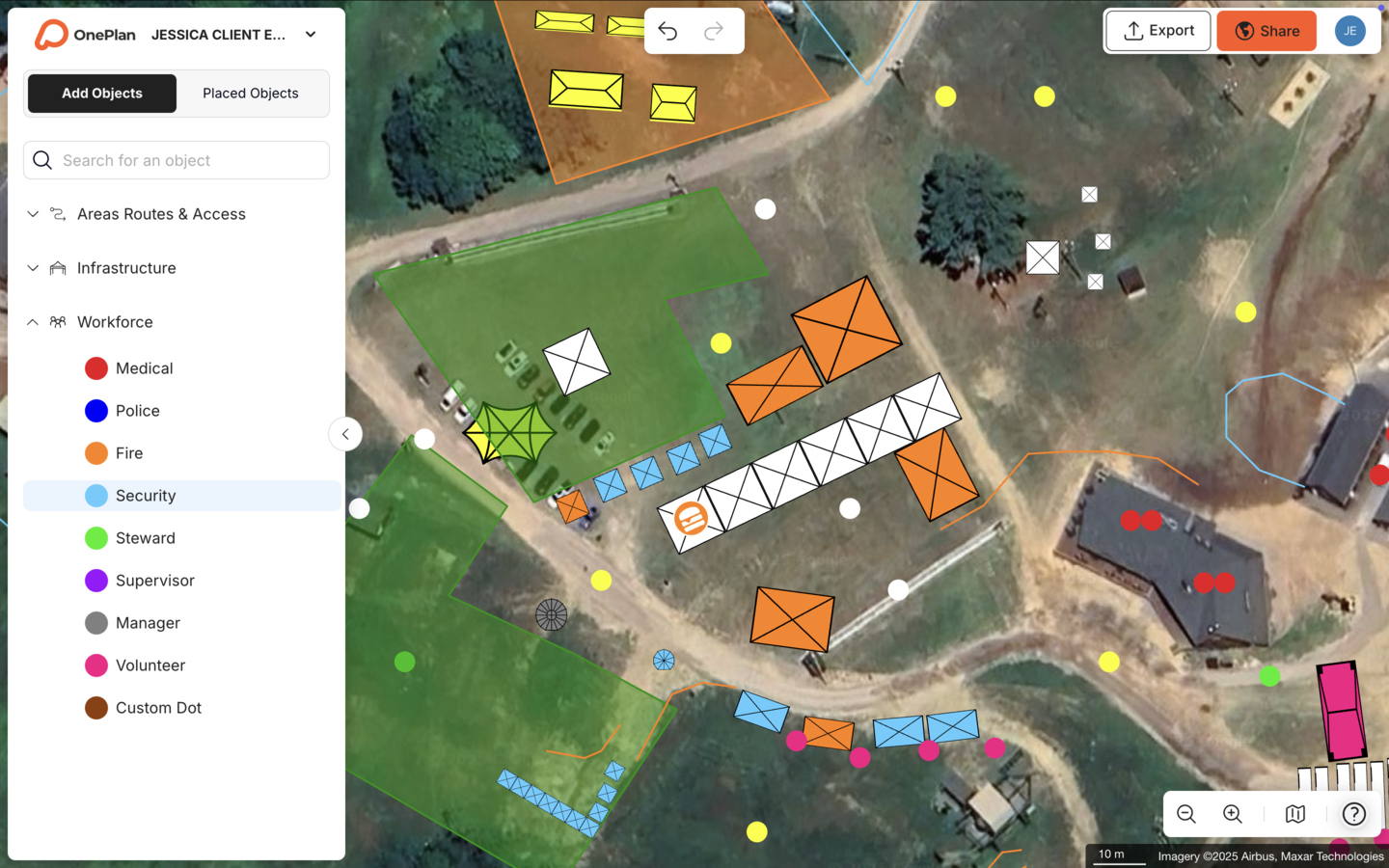
A permit-ready site map is not a sketch. It is a to-scale, geo-accurate document that every stakeholder, including operations, security, fire, medical, and local authorities, can read and act on. Expert site-mapping guidance for 2026 recommends drawing the perimeter first to define the licensed area, then blocking out broad zones, such as arena, traders, and camping, with distinct colors before adding infrastructure detail, because most site disputes involve boundaries.
A compliant event site map must show:
- Stages, grandstands, and performance areas
- All access and egress routes, including emergency vehicle lanes that must remain clear at all times
- First-aid stations, fire points, and assembly areas
- Vendor and catering placement
- Parking areas, road closures, and pedestrian flow paths
- Toilets and welfare facilities
- Generator and power source locations
- Signage and information points
Esri’s Special Event Operations guidance states that an event site map provides a common reference for planning, operating, and promoting each event, and that public safety planners should create operations maps of resources that complement the incident action plan by using information from the event site map.
OnePlan produces this kind of map to scale on a live satellite or street map, with drag-and-drop objects for every infrastructure element listed above. The crowd-capacity calculator lets you outline any standing area and instantly see its safe capacity. The arrival and exit calculators estimate queue length, queue time, and exit flow, and these figures feed directly into your safety plan. Plans export to high-resolution PNG at up to A0, ready for permit submissions.

See how the crowd-capacity and arrival/exit calculators generate permit-ready figures in minutes, and start planning your first event free in OnePlan.
5. Security Staffing and Crowd Capacity Numbers
This section documents the security staffing plan and zone-by-zone capacity figures that authorities use to assess whether the event is safely resourced.
Rauma city guidelines address the need for trained security for events, with the police determining the final minimum on a case-by-case basis, which serves as an illustrative example because ratios vary by jurisdiction. Industry guidance notes that a structured security plan is recommended for large crowds, with a ratio of one security officer per 100 attendees.
For each zone on your site map, document:
- Zone name and boundaries, referencing your OnePlan map grid
- Maximum standing capacity for that zone
- Number of security personnel assigned
- Entry and exit points serving the zone
- Alcohol service status (yes or no) and management approach
OnePlan’s standing crowd-capacity calculator lets you outline any zone on your to-scale map and instantly generate a defensible capacity figure. Those figures populate this section of the template directly, replacing manual estimates with accurate, documented calculations. You can also request a short walkthrough to see how these tools support your security and crowd plans.
Medical and First Aid Requirements Checklist
Use this checklist to confirm your medical provision meets the minimum standard for your event scale. Requirements vary by jurisdiction, so always confirm with your local authority and any relevant health department.
- First-aid station or stations marked on the to-scale site map with clear signage
- Automated External Defibrillator (AED) at each first-aid station
- Stretcher, oxygen, and basic life-support supplies at each station
- Named Medical Lead with direct radio contact to Event Director
- Ambulance access route identified and kept clear on the site map
- Nearest emergency department address and travel time documented
- Heat-illness protocol, including shade, water, and cooling, in place for outdoor events
- Crowd-crush and mass-casualty escalation procedure documented
- Medical staffing levels reviewed against event scale, using the factors below
What Level of Medical Care Your Event Needs
Medical provision scales with event size, type, duration, and risk profile. UK industry guidance such as the Purple Guide emphasizes risk assessment rather than fixed attendance-based ratios for determining medical staffing at events, and these figures remain illustrative while local regulations take precedence.
Key factors that increase medical requirements include:
- Outdoor setting with high temperatures or El Niño-driven weather risk
- Alcohol service over an extended period
- High-energy performance environment, such as crowd surges or mosh areas
- Attendee demographics, including elderly attendees, children, or attendees with medical conditions
- Multi-day or camping format, which increases worker fatigue and overnight medical incidents
- Remote location with extended ambulance response times
Research on mass-gathering medical care shows that the presence of on-site physicians significantly reduced ambulance transports at a large motorsports event in California, and that treat-and-release protocols at a 450,000-attendee concert kept ambulance transfers below 1 percent of medical presentations. Coordinate your medical plan with local EMS and the relevant hospital district.
6. Step-by-Step Emergency Response Procedures
Each procedure below should be printed and held by every role with stop or evacuation authority. Adapt trigger points to your specific site and risk matrix.
Medical emergency:
- First responder on scene radios Medical Lead with location, using the site map grid reference.
- Medical Lead assesses and dispatches the nearest first-aid team.
- If an ambulance is required, Operations Lead clears the designated vehicle access route immediately.
- Event Director is notified, and Communications Lead prepares PA messaging if crowd management is needed.
- Incident is logged with time, location, nature, and outcome.
Severe weather, including heat, storm, or flooding:
- Weather monitoring lead checks the forecast every two hours from 48 hours before the event.
- When a pre-agreed temperature or AQI threshold is reached, Event Director convenes the emergency team.
- Team decides to continue, relocate, delay, or cancel using pre-written trigger criteria.
- Communications Lead activates pre-approved PA and social media messaging.
- Shelter locations, marked on the site map, are opened and stewarded.
Lost person, adult or child:
- Report is received at any information point or by any steward.
- Description is relayed to all security and steward radios immediately.
- Lost-children facility, marked on the site map, is activated for minors.
- If the person is not located within 30 minutes, Event Director is notified and the police liaison is contacted.
Evacuation:
- Event Director or authorized role issues an evacuation order via radio and PA.
- Stewards move to pre-assigned exit points, marked on the site map, and direct crowd flow.
- Emergency vehicle access routes are kept clear, with no attendees on designated lanes.
- Assembly points are activated, and head counts are conducted by zone leads.
- Event Director, in consultation with emergency services, makes an all-clear or escalation decision.
7. Post-Event Review and Continuous Improvement
A structured post-event review turns each event into a safer one. Esri’s Special Event Operations guidance recommends after-action briefings that review activities, incidents, and responses to improve planning and operational procedures for future events.
Complete the following within 72 hours of event close:
- Confirm whether all risk matrix controls were implemented as planned, and document any gaps.
- Record how many medical incidents occurred and what the outcomes were.
- Review whether any crowd density thresholds were approached or exceeded.
- Note whether any emergency procedures activated and assess their effectiveness.
- Capture feedback from security, medical, and operations leads.
- Identify any near-misses that should be added to next year’s risk matrix.
- Update the OnePlan site map to reflect as-built positions for reuse next year.
Store the completed review alongside the safety plan and site map export. Many permitting authorities request post-event documentation as a condition of future permits.
Frequently Asked Questions
Can I use this template for any event size?
The seven-section structure scales from a 150-person community fair to a 50,000-person music festival. Smaller events will have shorter risk matrices and simpler chain-of-command tables. Larger events will require more detailed medical plans, security staffing schedules, and zone-by-zone capacity documentation. The key is to complete every section honestly rather than leaving fields blank, because a partially completed plan is a common reason permit applications are returned.
How does this template differ for festivals versus corporate events?
The structure stays the same, but the content differs significantly. Festivals draw large, anonymous crowds over many hours with continuous arrival and departure, so Sections 3 and 4, covering the risk matrix and security or crowd numbers, will be more detailed, with emphasis on crowd surge, alcohol management, perimeter control, and weather contingencies. Corporate events involve known, invited groups for defined windows, so Section 2, the chain of command, and the emergency response procedures tend to be simpler, while access control and VIP protection may require more attention. Always tailor the risk matrix to your specific audience demographics, venue configuration, and event duration.
What regional differences should I be aware of?
Requirements vary significantly by country and, within the United States, by state and municipality. As illustrative examples, Finland’s Rescue Act requires an emergency plan for public events where at least 200 people are expected to be present at the same time. Waterbury, Vermont’s permit mandates a full safety plan for certain events. In Rauma, Finland, the safety plan for a public event is submitted to the Rauma Police Station and the rescue plan to the fire inspectors of the Rauma Fire Station, Satakunta Rescue Department. Always check with your local authority, fire department, and any relevant licensing body before submitting. This template provides a comprehensive starting framework, and your local requirements may add to or modify specific sections.
How does OnePlan help me complete this template?
OnePlan generates the to-scale site maps and standing crowd-capacity figures that populate Sections 3 and 4 of this template. You drag and drop infrastructure objects, including stages, first-aid stations, crowd barriers, toilets, generators, and access routes, onto a live satellite or street map, outline crowd areas to get instant standing capacity calculations, and use the arrival and exit calculators to estimate queue times and exit flow. The finished map exports to a high-resolution PNG at up to A0 size, ready to attach to your permit application. Everything placed on the map also generates an automatic Bill of Quantities, which helps confirm that your infrastructure matches the safety plan’s requirements.
Do I need specialist software skills to use OnePlan?
No. OnePlan is drag-and-drop and runs entirely in a web browser, with nothing to download or install. It was built for event and operations professionals, not engineers, so you can sign up and start placing objects on your map within seconds. Your first event is free, up to 25 objects, with no payment details required. If you want structured guidance, the free OnePlan Academy course walks you through the platform step by step and issues a verified completion certificate you can share on LinkedIn.
Conclusion
A permit-ready event safety plan follows seven modular sections: Event Overview, Chain of Command, Risk Assessment Matrix, Security and Crowd Numbers, Emergency Response Procedures, Medical and First Aid, and Post-Event Review. Each section builds on the one before it, and the whole document is only as strong as the accuracy of the site map and crowd-capacity data that underpin it.
That is where OnePlan fits. To-scale site maps, standing crowd-capacity calculations, and arrival and exit flow estimates replace guesswork with defensible, documented figures that permitting authorities accept. The same platform used at the Paris 2024 Olympic Games is available free for your first event, so you can start planning with professional-grade tools today.
Start planning today in OnePlan, with no payment details required until you scale beyond your first event.