
Written by: Paul Foster, Founder, CEO, OnePlan
Key Takeaways
- An ingress egress plan for a city fireworks display coordinates arrival routes, safety buffers, one-way exits, and emergency lanes to meet 2026 fire-code setbacks and crowd-flow requirements.
- Traditional tools like PowerPoint, Excel, and Google Maps create fragmented versions across departments, while OnePlan delivers a single, browser-based, to-scale map that every stakeholder edits simultaneously.
- The 8-step operational playbook covers establishing safety buffers, identifying choke points, designing arrival corridors, implementing one-way egress, planning reversible lanes, coordinating transit, reserving emergency access, and exporting permit-ready deliverables.
- OnePlan’s area, arrival, and exit calculators plus real-time collaboration turn regulatory requirements into a permit-ready layout without CAD licenses or multiple site visits.
- See how a single shared map can cut planning time and deliver a defensible fireworks-display layout.
8-Step Ingress & Egress Checklist for City Fireworks
These eight steps form the operational backbone of a defensible ingress egress plan for a city fireworks display. Each step references the OnePlan tools that execute it on a single live map.
- Establish the safety buffer first. Plot the fallout radius on your map before routing a single pedestrian. Under the Fireworks for Freedom Act (H.R.8593, introduced April 30, 2026), local governments retain authority over fireworks displays, so confirm your jurisdiction’s specific code. As an illustrative benchmark, industry guidance recommends appropriate spectator distances based on shell size. Use OnePlan’s area calculator to draw that buffer to scale on a live satellite map so every department sees the same boundary.
- Identify street-grid choke points. Overlay your city’s arterial grid and mark every intersection, bridge, underpass, and narrow corridor within the spectator zone. In 2024, post-fireworks traffic leaving Hoboken lasted over six hours, prompting a 2026 Limited Travel Access Plan that closed key waterfront streets from 8 a.m. onward. Identify those pressure points on your map before the event, not after.
- Design dedicated arrival corridors. Assign separate pedestrian and vehicle arrival routes that do not cross the fallout zone. Use OnePlan’s traffic-management objects to draw road closures, access points, and directional arrows directly on the street map. Run the OnePlan arrival calculator to estimate queue length and queue time at ticket-check and security-screening points, then widen or multiply lanes accordingly.
- Implement a one-way egress system. Convert arrival corridors to exit-only after the display ends. Event security guidance recommends using barriers to create one-way walking routes in narrow areas and positioning staff beyond exit gates to prevent bunching outside the venue. Place crowd-barrier objects in OnePlan to model the physical corridor before ordering a single panel.
- Plan reversible lanes on arterial streets. Where your street grid allows, designate an arterial lane for inbound traffic before the event and reverse it for outbound flow afterward. KYTC guidance identifies arterials with continuous directional demand and defined control points as the best candidates for reversible-lane operation. Mark lane-direction changes, signal-timing windows, and control points on the OnePlan map so traffic and police teams see the same plan.
- Coordinate transit integration. Map bus drop-off and pick-up zones, shuttle loops, and rail station exits as named points of interest in OnePlan. Use the OnePlan exit calculator, which uses exit width, crowd size, and flow rate, to confirm that transit staging areas can absorb post-event volume without creating a secondary bottleneck off-site.
- Reserve and mark emergency vehicle lanes. Designate at least one dedicated emergency-access corridor that remains clear throughout the event. Clark County, Nevada (illustrative; requirements vary by jurisdiction) requires monitors whose sole duty is to enforce crowd control around the display area and fallout zone, each equipped with radios to communicate status to the lead technician. Place monitor and spotter workforce dots on the OnePlan map with assigned shift times and radio notes so every stakeholder knows who is where.
- Export and share the plan. Export a high-resolution PNG map and a Bill of Quantities CSV covering every barrier, sign, and staffing dot placed on the map. Share a live view-only link with fire, police, traffic, and operations teams so every department works from the same current version, not a PDF emailed three days ago.
Mapping the Recommended Safety Zone Around a Fireworks Display
The first step in the checklist above referenced establishing a safety buffer, and this section explains how that buffer is defined and used on the map. Safety buffer requirements for a city fireworks display are set by local fire codes and the Authority Having Jurisdiction (AHJ) in your municipality, so always confirm the applicable rules with your local fire marshal before finalizing any layout.
As an illustrative reference, industry guidance recommends appropriate spectator distances based on shell size. Some jurisdictions layer additional fallout-zone requirements on top of that base formula. Minneapolis, Minnesota (illustrative), requires a special event permit for all fireworks displays and compliance with the Minnesota State Fire Code, including accessibility and ingress/egress requirements under Chapter 1341 of the Minnesota State Building Code.
OnePlan’s area calculator lets you draw the fallout radius directly on a live satellite map to scale, so the buffer is visible to every department editing the plan, not buried as a number in a PDF. Once the buffer is drawn, teams plan ingress and egress routes, spectator zones, and emergency lanes outside it, because every department works on the same map.

How to Plan a Fireworks Display on a Single Map
Planning a city fireworks display involves four parallel workstreams: regulatory compliance, site layout, crowd flow, and stakeholder coordination. Many municipal teams struggle because these workstreams run in separate tools, so fire gets one map, police get another, and operations works from a third.
The City of Greater Dandenong’s Festivals and Events team organizes events including a New Year’s Eve fireworks display. Their team reported: “For our New Year’s Eve fireworks, we needed to set a safe exclusion zone, and OnePlan’s measuring tool was invaluable. It saved us from making numerous site visits or using inaccurate maps.”
As noted earlier, H.R.8593 preserves local government authority over fireworks safety requirements, so your AHJ sets the binding rules. OnePlan acts as the execution layer and converts those regulatory requirements into a to-scale, permit-ready layout that every department can review and edit without a CAD license or an engineering degree.
Permit-Ready Ingress Egress Plan PDF for Fireworks
A PDF export of your ingress egress plan is a standard deliverable for permit applications, pre-event briefings, and on-site command posts. When that PDF is built in PowerPoint or Canva, the underlying map is not to scale, so distances become guesswork and fire or police reviewers cannot fully trust the layout.
OnePlan exports a high-resolution PNG map (up to A0, print-ready) directly from the live, to-scale plan, along with a Bill of Quantities CSV that lists every barrier, sign, workforce dot, and traffic object placed on the map. Stadium, the UK security and traffic-management firm, used OnePlan to plan Coventry Moves, an event with over 400 road closures across 7 procession routes and 110 stakeholders, and reduced the time to produce eight traffic management maps from a full day in CAD to about two hours. The same export workflow applies to a city fireworks display, where one afternoon of planning produces a permit-ready map and a procurement-ready inventory.
The North Texas Tribute Jam’s organizer noted that sharing detailed plans for roadblocks, crowd control, and traffic management with the City of Lewisville’s Health and Safety Department meant getting necessary approvals quickly and without headaches. A to-scale, exportable OnePlan map is the document that makes that conversation fast. Once that map is approved, the next operational priority is designing the physical crowd-flow system that will execute the plan on event day.
Designing a One-Way Egress System for Fireworks Crowds
A one-way egress system is the single most effective physical intervention for post-fireworks crowd flow. When tens of thousands of spectators leave simultaneously, bidirectional pedestrian movement creates dangerous pressure at narrow points. McGill University researchers found in 2026 that dangerous conditions develop gradually through repeated physical contact rather than emerging suddenly, so pre-event corridor design, not reactive management, becomes the critical intervention.
A 2026 systematic review of crowd-management studies found that combining one-way pedestrian flows, physical barriers, real-time monitoring, and trained personnel can help reduce peak crowd density and bottleneck duration compared to single-intervention approaches.
In OnePlan, crowd barriers, fencing, and directional signage objects are placed on the live map to model the physical one-way corridor before a single panel is ordered. The Bill of Quantities export then tells procurement exactly how many barrier segments are needed, so no one re-counts on site.
Emergency Vehicle Access for Fireworks Displays
Emergency vehicle access is a non-negotiable lane that must be planned before spectator routes, not after. Clark County, Nevada (referenced earlier for monitor requirements), also requires at least one fire inspector at every outdoor fireworks display and may require a stand-by engine.
Hoboken’s 2026 July 4 plan enforced temporary no-parking zones from 4 a.m. July 4 through 2 a.m. July 5 with zero tolerance and towing at owner expense, after prior years saw drivers abandon vehicles in illegal areas and block emergency routes. That outcome, blocked emergency lanes, reflects a plan that was not enforced on the ground because the layout was not clear to every stakeholder in advance.
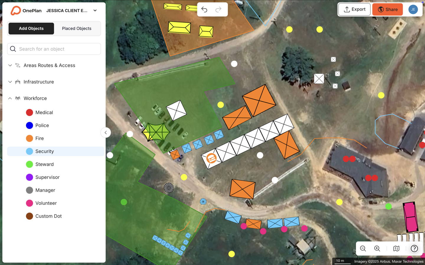
In OnePlan, emergency vehicle lanes are drawn as named route objects on the live map, with workforce dots placed for monitors and spotters at their assigned positions. Every department, including fire, police, and operations, sees the same lane on the same map in real time, which closes the version-control gap that leaves one team working from an outdated layout on event day.
Staggered Entry Strategy for Fireworks Events
Staggered entry distributes arrival load across a longer window and reduces peak queue depth at security screening and ticket-check points. A 2026 systematic review cited evidence that staggered start times during a marathon effectively reduced sudden crowd surges, and that a predictive machine learning model optimizing gate scheduling achieved a 27% reduction in simulated congestion time.
Use the OnePlan arrival calculator to model queue length and queue time for each timed entry window. If the calculator shows a 45-minute queue at a single gate during the peak window, the fix is visible before event day, so you can add a gate, widen the lane, or extend the staggered window. Crowd management guidance recommends separating ticket checking from bag screening, clearly labeling lane purpose (general admission, accessible, staff), and keeping supervisors mobile behind the lanes rather than only at the front, and planners can map all of these as named lanes and workforce dots in OnePlan before the event briefing.
Signage for staggered entry must be placed at decision points before spectators reach the gate. Festival planning guidance recommends placing wayfinding signs roughly 30 meters before forks, intersections, and entry points to give attendees time to read and choose routes without stopping and creating bottlenecks. Place those sign objects on the OnePlan map at the correct locations so the Bill of Quantities export captures every sign needed for procurement.
Staffing and Signage Checklist for Fireworks Night
Staffing ratios and sign placement standards must be confirmed with your local AHJ and event safety advisors, because requirements vary by jurisdiction and event size. The following illustrative benchmarks come from published industry guidance and should be adapted to your specific event.
Staffing reference points from published 2026 industry guidance:
- Most events need 1 registration staff member for every 100 to 150 attendees per hour at check-in desks.
- Ticket scanning is faster, and one scanner processes approximately 400-600 attendees per hour, so you may need fewer scanning stations than registration desks for the same crowd.
- Parking operations do not follow a universal attendant-to-stall ratio, because appropriate ratios depend on facility type, payment method, automation level, and peak demand pattern.
- Beyond fixed staffing ratios, large events often benefit from a layered wayfinding approach that combines physical signage with trained staff at decision points such as junctions and entry areas.
Signage placement standards from published guidance:
- Mount wayfinding signs at eye level with high luminance contrast and concise messages.
- Place temporary outdoor signs at appropriate intervals in open spaces and immediately before turns.
- Reserve red for warnings, use green or blue for guidance, and place symbols to the left of text.
In OnePlan, every staff member is placed as a named workforce dot with assigned role, shift times, and equipment notes. Every sign is placed as a point-of-interest object at its correct map location. The Bill of Quantities export then produces a complete staffing and signage inventory, so you do not need a separate spreadsheet.
Contingency and Evacuation Planning for Fireworks
A contingency plan for a city fireworks display covers three scenarios: weather cancellation before ignition, mid-display abort, and post-event crowd emergency. Each scenario requires pre-mapped hold-and-release zones, reversible-lane activation sequences, and a sample timeline that every department has reviewed in advance.
Large-event crowd management research identifies holding zones to regulate flow and controlled release of groups as useful interventions for emotional or cultural gatherings, and structured crowd management can reduce incidents. Map those hold zones as named crowd areas in OnePlan with standing capacity figures from the crowd capacity calculator, so every department knows the maximum number of people each zone can absorb before the next release.
A sample contingency timeline for a 10,000-person municipal fireworks display:
- T-minus 90 minutes: Gates open, staggered entry begins, and the arrival calculator confirms queue depth is within plan.
- T-minus 30 minutes: All emergency vehicle lanes are confirmed clear, and monitor and spotter positions are confirmed on the map.
- T-zero: Display begins, and one-way egress corridors are pre-staged with barriers in place.
- T-plus 5 minutes (display end): Hold-and-release protocol activates, and the first zone is released toward transit and parking.
- T-plus 15 minutes: Reversible arterial lane activates for outbound flow, and the exit calculator confirms corridor capacity.
- T-plus 60 minutes: Final zone is released, and emergency lanes remain clear until fire and police leads confirm the site is clear.
Research by crowd dynamics expert G. Keith Still identifies the egress concentration phase, typically 15–30 minutes post-event, as the highest-risk window at stadium and large public events. Your hold-and-release protocol must be designed to manage that window, and it must be visible on the same map that fire, police, and operations are all working from.
Model your contingency timeline and hold zones in OnePlan — your first event is free, or book a 15-minute demo to see the crowd calculators in action.
Conclusion
A defensible ingress egress plan for a city fireworks display is not a PDF attached to an email, but a live, to-scale map that fire, police, traffic, and operations teams edit together from safety-buffer calculation through post-event egress release. Every step in this playbook, from fallout-radius buffers and one-way corridors to staggered entry modeling and contingency timelines, is executable in OnePlan on a single shared map that exports to a permit-ready layout and a procurement-ready Bill of Quantities.
Eagle Mountain City achieved a 5x ROI and cut planning time by 70% by replacing separate departmental maps with one OnePlan layout. Greater Dandenong (whose measuring-tool success was detailed earlier) achieved the same outcome, a defensible exclusion zone without multiple site visits. The single source of truth is not a nice-to-have for a city fireworks display, but the difference between a plan every department trusts and a last-minute compliance failure on event day.
Start planning your fireworks display on a single shared map — get started free at oneplan.io, where your first event is on us.
Frequently Asked Questions
What is the recommended safety zone around a fireworks display?
Safety zone requirements are set by your local fire code and the Authority Having Jurisdiction in your municipality, so there is no single national standard that applies everywhere in the United States. As an illustrative reference, industry guidance recommends appropriate spectator distances based on shell size, and some jurisdictions add fallout-zone requirements on top of that base formula. Always confirm the applicable rules with your local fire marshal before finalizing any layout. OnePlan’s area calculator lets you draw that buffer to scale on a live satellite map so every department, including fire, police, and operations, sees the same boundary on the same plan.
How do you create a one-way egress system for a fireworks event?
A one-way egress system uses physical barriers, staffed corridors, and directional signage to channel post-event pedestrian flow in a single direction and prevent the bidirectional pressure that builds at narrow exit points. The design process starts on the map, where you identify every exit corridor, calculate its width and capacity using the OnePlan exit calculator, place crowd-barrier objects along the corridor boundaries, and assign workforce dots to monitor positions. The Bill of Quantities export then tells procurement exactly how many barrier segments and signs to order. On event day, every staff member has been briefed from the same map that fire and police reviewed during permitting, so there is no version-control gap between the plan and the operation.
How does staggered entry work for a city fireworks display, and how do you model it?
Staggered entry divides the expected audience into timed arrival windows, such as gates opening at 6 p.m. for pre-registered early arrivals with general admission beginning at 7 p.m., to spread the arrival load and reduce peak queue depth at security screening. The OnePlan arrival calculator models queue length and queue time for each entry window based on the number of lanes, screening throughput, and expected arrivals per hour. If the model shows an unacceptable queue at a single gate during the peak window, the fix is visible before event day, so you can add a lane, widen the corridor, or extend the staggered window. Signage objects placed on the OnePlan map at decision points, roughly 100 feet before forks and entry gates, ensure spectators know which lane to use before they reach the front of the queue.
What emergency vehicle access requirements apply to outdoor fireworks displays?
Emergency vehicle access requirements are set by your local fire marshal and AHJ and vary by jurisdiction. As an illustrative example, Clark County, Nevada, requires at least one fire inspector at every outdoor fireworks display, may require a stand-by engine, and mandates monitors and spotters with radios whose sole duty is crowd control and hazard observation around the display and fallout zone. The number of monitors and spotters is determined by the Clark County Fire Department. Regardless of jurisdiction, the operational principle remains consistent: designate at least one dedicated emergency-access corridor that remains clear throughout the event, mark it on the to-scale map that every department is working from, and assign named staff to enforce it. In OnePlan, that lane is drawn as a named route object with workforce dots at assigned positions, so fire, police, and operations all see the same access corridor on the same live plan.
How does OnePlan replace PowerPoint, Excel, and Google Maps for a city fireworks display plan?
PowerPoint, Excel, and Google Maps each solve part of the problem but not the whole one. Screenshots are not to scale, so distances are guesswork. Spreadsheets capture inventory but cannot show spatial relationships. Google Maps provides a base image but has no event-specific objects, no crowd or traffic calculators, and no real-time collaboration for multiple departments. OnePlan combines all three functions on a single browser-based platform, with a live satellite or street map as the base layer, thousands of to-scale drag-and-drop objects such as barriers, signs, workforce dots, and vehicle lanes, intelligent arrival and exit calculators, and real-time collaboration so fire, police, traffic, and operations edit the same plan simultaneously. The result is a permit-ready, high-resolution map export and a Bill of Quantities CSV, both produced from the same source of truth with no re-keying and no version-control risk.