
Written by: Paul Foster, Founder, CEO, OnePlan
Key Takeaways for Your Parade Route Plan
- Parade ingress and egress planning now requires documented, accurate, coordinated plans that satisfy stricter safety reviews from permitting, police, and fire authorities.
- PowerPoint, Excel, and Google Maps lack to-scale accuracy and real-time collaboration, which makes them unreliable for multi-agency parade planning.
- Effective ingress planning covers to-scale route mapping, staging zones, spectator corridors, perimeters, public transport, and detoured traffic routes.
- Effective egress and emergency access planning covers dispersal zones, barrier removal sequences, exit corridors, road reopening orders, emergency lanes, and command posts.
- OnePlan provides a single, live, to-scale map that replaces fragmented workflows and produces permit-ready plans, so book a 15-minute demo to see how your team can streamline parade planning today.
Ingress Planning on a Single Live Map
Ingress planning defines how spectators, participants, and vehicles reach the parade route safely without creating bottlenecks. These steps follow FHWA Chapter 6 principles for temporary traffic control and take place on a live, to-scale map in OnePlan. Always confirm requirements with your local fire, police, and permitting authorities, because rules vary by jurisdiction.

- Map the route to scale. Open OnePlan and set your base layer to satellite or street map. Trace the full parade route as a to-scale line so every measurement, including road width, staging length, and turning radius, reflects real-world dimensions. This approach removes the guesswork that comes from non-scaled screenshots.
- Define staging zones. Place participant staging areas at the parade start point and size them accurately for the number of floats, marching bands, and vehicles. Use OnePlan drag-and-drop objects for vehicles, tents, and crowd barriers, which all stay to scale as you zoom.
- Plot spectator arrival corridors. Every parade plan must address where cars park and how the crowd moves to the route. Mark pedestrian approach paths from parking areas and transit stops. Add OnePlan points-of-interest icons for crossings, entry gates, and information points so routes stay clear and intuitive.
- Lay out the outer perimeter. An outer perimeter using traffic cones, barrels, and officers detours general traffic and identifies problem vehicles attempting to bypass the route. Place these objects on the map and use OnePlan Bill of Quantities to calculate exactly how many cones and barriers to order.
- Coordinate public transport. Mark bus stops, shuttle drop-off points, and park-and-ride locations on the same map. Use OnePlan free arrival calculator to estimate queue lengths and ticket-check times at each entry point. Replace rough estimates with figures you can defend to safety partners.
- Route detoured traffic. Draw alternative vehicle routes on the map for traffic diverted away from the closure zone, consistent with FHWA Chapter 6 temporary traffic control guidance. Stadium planned Coventry Moves, a complex multi-route event with hundreds of road closures, entirely in OnePlan and cut planning time from over 200 hours to 75.
Egress Planning After the Parade Ends
Once you have mapped how people arrive at your parade route, the next critical step is planning how they leave. Egress planning governs how spectators and participants exit the route area safely once the parade concludes. Poorly planned dispersal remains one of the most common causes of post-event crowd incidents.

- Designate dispersal zones. Map clearly defined areas at the parade end point and at intervals along the route where crowds can disperse safely. Size each zone accurately in OnePlan and use the standing crowd capacity calculator to confirm it can hold the expected number of people at a safe density and meets your local fire and police capacity requirements.
- Plan removable barrier sequences. Document the order in which crowd barriers are removed so pedestrian flow opens progressively. Place each barrier on the map and note removal timing in the object label field so the event-day team has a clear sequence to follow.
- Map pedestrian exit corridors. Draw dedicated exit paths leading from dispersal zones to parking areas, transit stops, and surrounding streets. Use OnePlan free exit calculator, which uses exit width, crowd size, and flow rate, to estimate exit capacity and identify pinch points before event day.
- Coordinate road reopening sequence. A pre-determined parade route allows police and organizers to plan the shutdown and reopening sequence once and reuse it with minor improvements after each event. Document the reopening order on the same OnePlan map so traffic management and police work from one shared picture.
- Monitor pedestrian flow points. Place staff dots on the map at key dispersal intersections and assign each a role, shift time, and notes. This setup gives supervisors a live staffing picture instead of a disconnected spreadsheet.
Emergency Access Along the Route
Emergency access planning ensures that police, fire, and medical teams can reach any point along the route quickly, regardless of crowd density. Every parade plan must address how police, fire, and rescue personnel respond to emergencies within the route. Always follow your local jurisdiction requirements for emergency access widths and command post placement.
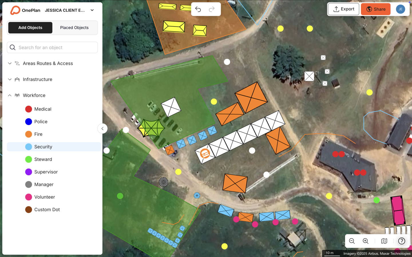
- Establish the inner perimeter. The inner perimeter is designed primarily to prevent impaired or hostile drivers from entering the crowd, using portable cement barricades, dump trucks, tractor-trailers, or flatbeds as vehicular barriers. Map each barrier type to scale in OnePlan so the plan stays accurate enough to share directly with police and permitting authorities.
- Map emergency corridors. Draw dedicated emergency vehicle lanes running parallel to or intersecting the parade route at regular intervals. Label each corridor with its minimum clear width and the vehicle types it must accommodate.
- Place command posts. Command post setups for parades must include high-ground observation positions for over-watch coverage of the linear route, plainclothes officers embedded within the crowd, and mobile response teams on standby for immediate intervention. Mark each command post, observation point, and mobile team staging area on the OnePlan map using workforce dots with assigned roles and radio channels noted.
- Position crowd managers and medical. Place first-aid posts and crowd manager positions at calculated intervals along the route. The National Park Service Event Planning Guide recommends that medical and crowd management resources be positioned based on anticipated crowd density and route length. Map these positions in OnePlan so every agency sees the same deployment picture.
- Share the plan with all agencies. Export a high-resolution map from OnePlan for permit submissions and share a live view-only link so police, fire, and medical teams always see the most current version. Eagle Mountain City eliminated the need to create separate maps for fire, police, and facilities by building one comprehensive, to-scale plan in OnePlan, cutting planning time by 70% and achieving a 5x ROI.
OnePlan Arrival and Exit Calculators for Crowd Flow
Two free OnePlan calculators remove guesswork at the most critical points in parade ingress and egress planning.
The Arrival Calculator estimates queue length and queue time for ticket checks and security screening at each entry point. Enter your expected arrival rate and screening throughput, and the calculator returns figures you can use to size staging areas and staff entry gates, with no manual math required.
The Exit Calculator uses exit width, crowd size, and flow rate to estimate exit capacity. Run it for each dispersal zone and exit corridor on your parade map to confirm the layout can handle your expected crowd before you order a single barrier.
Both calculators are free to use and built for events and operations teams, not engineers. Use them alongside your to-scale OnePlan map to produce defensible, permit-ready figures for every ingress and egress decision.
Parade-Day Timeline for Ingress, Egress, and Access
| Timeframe | Ingress & Egress Actions | Emergency Access Actions | OnePlan Task |
|---|---|---|---|
| 48 hours before | Confirm road closure permits, brief traffic management team on detour routes | Confirm emergency corridor widths with police and fire, finalize command post locations | Export final permit maps, share live view-only link with all agencies |
| 24 hours before | Deploy outer perimeter barriers and signage, test public transport coordination | Pre-position mobile response teams, confirm radio channels at each command post | Run arrival and exit calculators with final attendance estimate, update staffing dots |
| Event day: setup | Open spectator arrival corridors, staff entry gates and pedestrian crossings | Activate inner perimeter vehicle barriers, confirm over-watch positions are staffed | Use OnePlan map on mobile for real-time reference, confirm object placement matches plan |
| Event day: live | Monitor crowd flow at entry points, manage queue lengths against calculator estimates | Keep emergency corridors clear, keep mobile response teams on standby | Reference live plan for any real-time adjustments to staff positions |
| Post-event | Execute barrier removal sequence, reopen roads in planned order | Stand down command posts in sequence, confirm all emergency access lanes cleared | Update plan as template for next year's event |
Real-World Parade Planning Examples
Eagle Mountain City replaced a fragmented, multi-map workflow, with separate layouts for fire, police, and facilities, with a single OnePlan map shared across all departments. Events Manager Dawn Hancock, whose 70% time savings and 5x ROI were noted earlier, cut planning time from 8–10 hours down to a few hours per event. For parade planning, one live, to-scale plan for every agency removed version-control confusion and last-minute compliance issues.
Stadium (Coventry Moves), mentioned earlier for its dramatic time savings, also saw operational efficiency gains. Sign placement dropped from 5 minutes to under a minute each, and traffic management maps that previously took a full day in CAD were completed in 2 hours. The result was a permit-ready, stakeholder-ready plan produced in a fraction of the time.
Book a 15-minute demo to see OnePlan in action and see how your team can build a permit-ready parade plan on one live map.
Implementation Readiness Checklist for Your Team
Before building your parade ingress and egress plan in OnePlan, confirm the following items are in place.
- Team structure: Identify the lead planner, the “ring leader” who builds the map, and the departments that need access, including operations, traffic, police, fire, medical, and public works.
- Data sources: Gather the parade route, road closure boundaries, parking lot locations, transit stop coordinates, and any existing site plans or CAD-derived files converted to .png for import into OnePlan.
- Stakeholder list: List every agency and contractor who needs to view or contribute to the plan, and assign each a role, editable or view-only, in OnePlan.
- Approval workflow: Confirm which permits require a map submission, what format is required, high-resolution PNG is OnePlan export format, and the submission deadlines for your jurisdiction.
- Calculator inputs: Collect expected attendance, arrival rate, exit widths, and screening throughput figures so the arrival and exit calculators return accurate estimates.
- Compliance check: Confirm local fire, police, and permitting requirements for barrier types, emergency corridor widths, and crowd manager ratios, because these vary by state and municipality.
Common Parade Planning Pitfalls to Avoid
- Fragmented maps across departments: When police, fire, traffic, and operations each maintain their own plan in PowerPoint, Excel, Canva, Photoshop, Google Maps, or static screenshots, no one works from the same picture. Build one map in OnePlan and share it across every agency.
- Non-scaled layouts: A parade route drawn on a non-scaled screenshot often looks right but rarely is. Staging zones that appear adequate on paper may be too small for the actual number of floats, and dispersal areas may be undersized for the crowd. OnePlan to-scale base map removes this risk.
- Repeated site visits to measure by hand: The Beirut Marathon cut site visits from 20 down to two by measuring and planning remotely in OnePlan. Parade planners can follow the same approach and validate ingress and egress layouts from the desk first.
- Version-control chaos: Emailing static plan files back and forth means different agencies act on different versions. OnePlan real-time collaboration keeps every stakeholder on one live plan, with changes visible instantly.
- Underestimating exit capacity: Exit bottlenecks are among the most preventable parade safety failures. Use the OnePlan exit calculator to stress-test every dispersal zone before event day.
- Late permit submissions: Inaccurate or incomplete maps slow down approvals. OnePlan exports print-ready, high-resolution maps, up to A0, that meet the documentation standards most permitting authorities require.
Frequently Asked Questions for Local-Government Planners
How far in advance should parade ingress and egress planning begin?
Most community parades benefit from starting ingress and egress planning at least 8–12 weeks before the event date. Larger parades with multiple procession routes, significant road closures, or complex multi-agency coordination may require 6 months or more of lead time. Key milestones include route confirmation and permit submission, stakeholder briefings with police and fire, barrier and signage procurement, and a final plan review 48 hours before the event. Starting in OnePlan early turns the plan into a living document that every agency can access and contribute to throughout the process, instead of a static file that gets emailed around at the last minute.
What is the minimum emergency corridor width for a parade route?
Emergency corridor width requirements vary by jurisdiction and are set by local fire and police authorities, so no single universal standard exists. As a general principle, corridors must be wide enough to accommodate the largest emergency vehicle likely to respond, typically a fire apparatus. Always confirm the required minimum width with your local fire marshal and police department before finalizing your plan. In OnePlan, you can measure and label every emergency corridor to scale so the documented width stays accurate and verifiable for permit submissions.
How do I coordinate ingress and egress planning with police, fire, and traffic agencies?
The most effective approach uses one shared, to-scale map that every agency can view and reference, instead of sending each department a separate static file. In OnePlan, you can share a live view-only link with police, fire, traffic management, and any other stakeholder so they always see the most current version of the plan. For formal permit submissions, export a high-resolution map directly from OnePlan. This approach removes the version-control confusion that comes from emailing multiple files and ensures every agency works from the same picture on event day.
What tools should I use instead of PowerPoint or Google Maps for parade planning?
PowerPoint, Google Maps, and similar tools are not built for parade ingress and egress planning because nothing in them is to scale. A route that looks correct on a screenshot may have staging zones that are too small, dispersal areas that are undersized, or emergency corridors that do not meet the required width. OnePlan uses a live satellite or street map as its base layer, so every object, including barriers, cones, command posts, and staff positions, stays accurately to scale as you zoom. It is drag-and-drop simple, free for your first event, and produces the high-resolution, permit-ready exports that permitting authorities expect.
How do I estimate queue lengths and exit capacity for a parade?
Use OnePlan free calculators instead of estimating by eye or relying on rough rules of thumb. The arrival calculator estimates queue length and queue time at entry points based on your expected arrival rate and screening throughput. The exit calculator uses exit width, crowd size, and flow rate to estimate exit capacity for each dispersal zone. Both calculators are free to use and designed for events and operations professionals. Run them against your to-scale OnePlan map to confirm that your ingress and egress layout can handle your expected crowd before you order any infrastructure or submit any permit.
Conclusion and Next Steps for Your Next Parade
Parade ingress and egress planning has become too complex and too scrutinized for fragmented manual methods to keep up. When police, fire, traffic, and operations teams each work from their own version of a non-scaled map, the risk of a last-minute compliance failure or an event-day safety incident increases sharply. A single, to-scale, collaborative map that every agency works from, built on FHWA Chapter 6 principles and updated in real time as the plan evolves, provides a safer path.
OnePlan serves as that single source of truth. From the first route trace to the final permit export, every ingress zone, egress corridor, emergency lane, command post, and staff position lives on one live map that stays accurate, shareable, and current. The arrival and exit calculators replace guesswork with defensible figures. The Bill of Quantities turns the map into a procurement list, and the high-resolution export goes straight to your permitting authority.
Local-government events teams from Eagle Mountain City to Coventry already use this approach, cutting planning time, reducing site visits, and delivering safer events with less effort. Your next parade can follow the same model.